IMAGES TAKEN NEAR TO
Tomintoul, BALLINDALLOCH, AB37 9HB
Introduction
This page details the photographs taken nearby to AB37 9HB by members of the Geograph project.
The Geograph project started in 2005 with the aim of publishing, organising and preserving representative images for every square kilometre of Great Britain, Ireland and the Isle of Man.

There are currently over 7.5m images from over14,400 individuals and you can help contribute to the project by visiting https://www.geograph.org.uk
Image Map
Images are licensed for reuse under creativecommons.org/licenses/by-sa/2.0
Notes
- Clicking on the map will re-center to the selected point.
- The higher the marker number, the further away the image location is from the centre of the postcode.
Image Listing (3 Images Found)
Images are licensed for reuse under creativecommons.org/licenses/by-sa/2.0
Image
Details
Distance
1
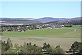
Tomintoul from Victor Gaffney's Cairn
The long straight line of the village is well seen from this direction.
Image: © Anne Burgess
Taken: 12 May 2009
0.17 miles
2
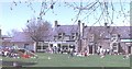
Tomintoul Square
Tomintoul is a typical planned village of the late 18th century, with straight wide streets and a central square.
Image: © Anne Burgess
Taken: Unknown
0.19 miles
3
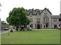
Gordon Arms Hotel, Tomintoul
In, reputedly, the highest village in the Highlands
Image: © Stanley Howe
Taken: 21 Jul 2004
0.21 miles