IMAGES TAKEN NEAR TO
Denhead Terrace, BALLINDALLOCH, AB37 9BL
Introduction
This page details the photographs taken nearby to Denhead Terrace, AB37 9BL by members of the Geograph project.
The Geograph project started in 2005 with the aim of publishing, organising and preserving representative images for every square kilometre of Great Britain, Ireland and the Isle of Man.

There are currently over 7.5m images from over14,400 individuals and you can help contribute to the project by visiting https://www.geograph.org.uk
Image Map
Images are licensed for reuse under creativecommons.org/licenses/by-sa/2.0
Notes
- Clicking on the map will re-center to the selected point.
- The higher the marker number, the further away the image location is from the centre of the postcode.
Image Listing (6 Images Found)
Images are licensed for reuse under creativecommons.org/licenses/by-sa/2.0
Image
Details
Distance
1
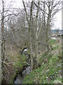
Burn of Pitchaish
This descends in a steep valley to join the Spey near Blacksboat.
Image: © Jonathan Billinger
Taken: 22 Apr 2008
0.06 miles
2
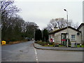
Marypark
A hamlet centred around the junction of the B9138 with the A95 in Speyside.
Image: © Jonathan Billinger
Taken: 22 Apr 2008
0.07 miles
4
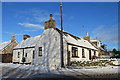
Cottage in Marypark
The front elevation has been harled, but the gable and side elevations have been painted over, so you can see the texture of the stone through the paint.
Image: © Anne Burgess
Taken: 17 Jan 2018
0.09 miles
5
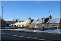
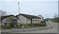
Marypark
These cottages are on the A95 main road in Marypark.
Image: © Anne Burgess
Taken: 17 Jan 2018
0.10 miles