IMAGES TAKEN NEAR TO
Holland Street, ABERDEEN, AB25 3UJ
Introduction
This page details the photographs taken nearby to Holland Street, AB25 3UJ by members of the Geograph project.
The Geograph project started in 2005 with the aim of publishing, organising and preserving representative images for every square kilometre of Great Britain, Ireland and the Isle of Man.

There are currently over 7.5m images from over14,400 individuals and you can help contribute to the project by visiting https://www.geograph.org.uk
Image Map (Loading...)


Getting Data...Please wait
Leaflet Map data © OpenStreetMap
Images are licensed for reuse under creativecommons.org/licenses/by-sa/2.0
Notes
- Clicking on the map will re-center to the selected point.
- The higher the marker number, the further away the image location is from the centre of the postcode.
Image Listing (103 Images Found)
Images are licensed for reuse under creativecommons.org/licenses/by-sa/2.0
Image
Details
Distance
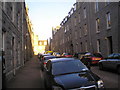
1
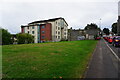
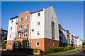
New Flats on Holland Street, Aberdeen
These new red brick flats fail to blend in with the traditional granite tenements which surround them.
Image: © Richard Slessor
Taken: 19 Sep 2006
0.01 miles
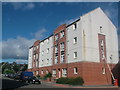
2
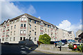
Flats
The design makes an effort to complement the granite tenement to the right.
Image: © Bill Harrison
Taken: 5 Oct 2008
0.02 miles
3
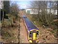
Aberdeen bound train
The train from Inverness is seen, from Hutcheon Street, close to arriving at Aberdeen station.
Image: © Richard Slessor
Taken: 13 Apr 2006
0.04 miles
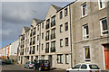
4
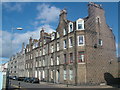
Granite Tenements on Holland Street, Aberdeen
These tenements were built in the late 19th Century and are beginning to show their age.
Image: © Richard Slessor
Taken: 19 Sep 2006
0.05 miles
5
Flats
One of a number of large apartment complexes in the back streets to the west of George Street.
Image: © Bill Harrison
Taken: 11 Oct 2008
0.05 miles
6
Flats
One of many modern blocks in this part of town.
Image: © Bill Harrison
Taken: 5 Oct 2008
0.06 miles
7
Hutcheon Street railway station (site), Aberdeen
Opened in 1887 on the Great North of Scotland Railway's line from Aberdeen (Joint) to Keith via the Denburn Valley, this station closed in 1937. The main line was later singled.
View north towards Kittybrewster and Keith. One of the platform edges can still just be made out amidst the undergrowth.
Image: © Nigel Thompson
Taken: 24 May 2017
0.06 miles
8
Fraser Street at sunset
Looking east from the corner of Fraser Street and Fraser Road.
Image: © Charlotte Lunn
Taken: 30 Oct 2010
0.07 miles
9
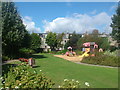
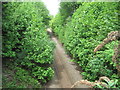
Playpark by Stafford Street, Aberdeen
A small playpark in open land between the tenements of Stafford Street and Lamond Place.
Image: © Richard Slessor
Taken: 19 Sep 2006
0.07 miles