IMAGES TAKEN NEAR TO
Ashgrove Court, ABERDEEN, AB25 3BA
Introduction
This page details the photographs taken nearby to Ashgrove Court, AB25 3BA by members of the Geograph project.
The Geograph project started in 2005 with the aim of publishing, organising and preserving representative images for every square kilometre of Great Britain, Ireland and the Isle of Man.

There are currently over 7.5m images from over14,400 individuals and you can help contribute to the project by visiting https://www.geograph.org.uk
Image Map (Loading...)


Getting Data...Please wait
Leaflet Map data © OpenStreetMap
Images are licensed for reuse under creativecommons.org/licenses/by-sa/2.0
Notes
- Clicking on the map will re-center to the selected point.
- The higher the marker number, the further away the image location is from the centre of the postcode.
Image Listing (29 Images Found)
Images are licensed for reuse under creativecommons.org/licenses/by-sa/2.0
Image
Details
Distance
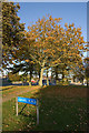
2
Gillespie Crescent towards Carnie Drive, Aberdeen
Image: © Ian S
Taken: 4 Oct 2022
0.07 miles
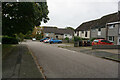
4
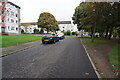
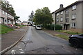
Ash-Hill Drive towards Cairncry Road, Aberdeen
Image: © Ian S
Taken: 4 Oct 2022
0.10 miles
6
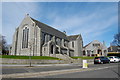
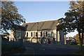
High Hilton Kirk, Hilton Drive, Aberdeen
The church, with church hall behind, dates from around 1935, when the High Kirk congregation migrated out from the city centre.
Image: © Bill Harrison
Taken: 20 Apr 2013
0.11 miles
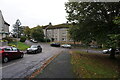
8
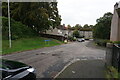
Cornhill Drive towards Ash-Hill Drive, Aberdeen
Image: © Ian S
Taken: 4 Oct 2022
0.11 miles