IMAGES TAKEN NEAR TO
Seaforth Road, ABERDEEN, AB24 5PU
Introduction
This page details the photographs taken nearby to Seaforth Road, AB24 5PU by members of the Geograph project.
The Geograph project started in 2005 with the aim of publishing, organising and preserving representative images for every square kilometre of Great Britain, Ireland and the Isle of Man.

There are currently over 7.5m images from over14,400 individuals and you can help contribute to the project by visiting https://www.geograph.org.uk
Image Map
Images are licensed for reuse under creativecommons.org/licenses/by-sa/2.0
Notes
- Clicking on the map will re-center to the selected point.
- The higher the marker number, the further away the image location is from the centre of the postcode.
Image Listing (90 Images Found)
Images are licensed for reuse under creativecommons.org/licenses/by-sa/2.0
Image
Details
Distance
1
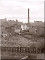
Houses on Erroll Street
Seen from a top-floor flat on King Street.
Image: © Richard Sutcliffe
Taken: Unknown
0.03 miles
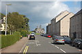
2

Seaforth Road, Aberdeen
Council houses on Seaforth Road, near Pittodrie Stadium.
Image: © Charlotte Lunn
Taken: 26 Sep 2009
0.04 miles
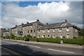
3
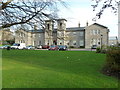
Sheltered housing complex, King Street, Aberdeen
Image: © Bill Harrison
Taken: 19 Nov 2011
0.04 miles
5
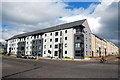
New flats...
...at the junction of King Street and Seaforth Road. Built on the site of a luxury car dealership.
Image: © Bill Harrison
Taken: 16 Aug 2014
0.05 miles
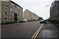
6
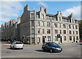
Junction of King Street and Seaforth Road, Aberdeen
The massive four-storey corner block has 1903 on the date-stone and "D. C." on the end wall, which are possibly the builder's initials?
Image: © Bill Harrison
Taken: 16 Aug 2014
0.05 miles
7
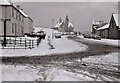
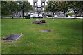
Erroll Place, Aberdeen
Looking on a wintery day after snow towards the gates and lodge (with pepperpot tower) of Trinity Cemetery.
Image: © Richard Sutcliffe
Taken: Unknown
0.06 miles
8
1930s Council flats, King Street, Aberdeen
As well as estates (Kincorth, Seaton, Hilton...) many isolated granite council blocks were built in the 1930s.
Image: © Bill Harrison
Taken: 16 Aug 2014
0.06 miles
9
Looking down Erroll Street, Aberdeen
Trinity Cemetery lodge in the distance... (see: http://www.geograph.org.uk/photo/2699676 )
Image: © Bill Harrison
Taken: 16 Aug 2014
0.06 miles
10
Turf Zone "KingMary"
On King Street, Aberdeen.
Image: © Ian S
Taken: 4 Oct 2022
0.07 miles