1
Hillhead Terrace, Spital, Aberdeen
The block is well named, and there are steep steps up from the street to access the houses.
Image: © Bill Harrison
Taken: 13 Aug 2016
0.02 miles
2
Spital
Spital is a small but distinctive district in Aberdeen, sitting on top of the hill between Old Aberdeen and the modern city centre. This row of granite houses have steeply sloping front gardens and steps up from the street.
Image: © Bill Harrison
Taken: 22 Sep 2008
0.03 miles
3
Former BT site, Froghall Terrace, Aberdeen
The buildings shown in
Image have been demolished but the site hasn't yet been redeveloped.
Image: © Stephen Craven
Taken: 3 Jul 2019
0.04 miles
4
Victorian wall-box, Spital, Aberdeen
The maker's name, W. T. Allen & Co, dates the box to between 1881 and 1901. The company is apparently still in business: http://businessnetwork.co.uk/business-directory/london/w-t-allen-and-co-ltd .
Image: © Bill Harrison
Taken: 13 Aug 2016
0.05 miles
5
Spital
New dwellings face the granite houses seen in http://www.geograph.org.uk/photo/975195
Image: © Bill Harrison
Taken: 22 Sep 2008
0.05 miles
6
The Red Lion
A popular pub with students and locals. The unusual carved sign between the two first-floor windows bears a date of 1906.
Image: © Bill Harrison
Taken: 22 Sep 2008
0.06 miles
7
High-up houses
The terrace to the west of Spital towers above the road.
Image: © Bill Harrison
Taken: 3 Aug 2012
0.06 miles
8
Old gateway to St Peter's Cemetery...
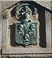
...off Spital. The entrance is now on King Street on the opposite side of the cemetery. For the Moir of Scotstoun arms above the gate, see: http://www.geograph.org.uk/photo/4363024 .
Image: © Bill Harrison
Taken: 26 Feb 2015
0.07 miles
9
Arms of Moir of Scotstoun...
...above the old gateway to St Peter's Cemetery off Spital. The blazon is: Argent three Negroes' heads couped proper banded of the first. Crest: a morthead (skull) with two leg-bones in saltire proper. Motto: non sibi sed cunctis (not for self but for all), according to Burke's General Armory (p. 692, 1884 edition). The rendition of the arms, which are a relic of their ancestor's crusader roots from the Battle of Teba (https://en.wikipedia.org/wiki/Battle_of_Teba ) in 1330, in bronze is highly unusual and distinctive. For the remains of the family mausoleum in the graveyard, see: http://www.geograph.org.uk/photo/4263195 . Thanks to Shawn Moir for information on the arms.
Image: © Bill Harrison
Taken: 26 Feb 2015
0.07 miles
10
Moir of Scotstoun mausoleum, St Peter's Cemetery, Aberdeen
The C-listed (see: http://data.historic-scotland.gov.uk/pls/htmldb/f?p=2200:15:0::::BUILDING:20061 ), semi-ruined structure apparently incorporates some remains of the medieval St Peter's chapel. For the genealogy of this extinct branch of the Moir family, who were mostly staunch Jacobites, see p 75 of "The Families of Moir and Byres" by A Mitchell Gill (publ. Edinburgh 1885), available as a download from http://archive.org
Image: © Bill Harrison
Taken: 30 Nov 2014
0.08 miles


