IMAGES TAKEN NEAR TO
Jute Street, ABERDEEN, AB24 3HB
Introduction
This page details the photographs taken nearby to Jute Street, AB24 3HB by members of the Geograph project.
The Geograph project started in 2005 with the aim of publishing, organising and preserving representative images for every square kilometre of Great Britain, Ireland and the Isle of Man.

There are currently over 7.5m images from over14,400 individuals and you can help contribute to the project by visiting https://www.geograph.org.uk
Image Map
Images are licensed for reuse under creativecommons.org/licenses/by-sa/2.0
Notes
- Clicking on the map will re-center to the selected point.
- The higher the marker number, the further away the image location is from the centre of the postcode.
Image Listing (125 Images Found)
Images are licensed for reuse under creativecommons.org/licenses/by-sa/2.0
Image
Details
Distance
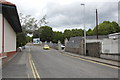
1
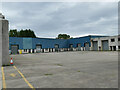
Canal Road Industrial Estate, Aberdeen
Occupying the site of a former 'preserving works', now home to the Drain Center and Plumb Center in uninspiring buildings that bear no comparison to the city's traditional architecture.
Image: © Stephen Craven
Taken: 3 Jul 2019
0.05 miles
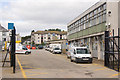
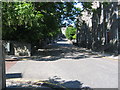
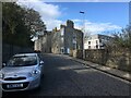
3
A look down Froghall Terrace, Aberdeen
Image: © Bill Harrison
Taken: 5 Feb 2012
0.07 miles
4
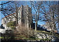
Former St Margaret's Episcopal Convent
A-listed: http://data.historic-scotland.gov.uk/pls/htmldb/f?p=2200:15:0::::BUILDING:19961. The episcopal convent closed its doors a few years ago and the complex is now, I believe, a Buddhist retreat.
Image: © Bill Harrison
Taken: 26 Feb 2015
0.09 miles
5
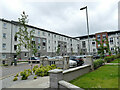
Spencer Court, Aberdeen
Modern low-rise apartments on the site of the former Aberdeen Jute Works.
Image: © Stephen Craven
Taken: 3 Jul 2019
0.10 miles
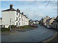
6
Canal Road, Aberdeen
The name commemorates the Aberdeenshire Canal, which disappeared as long ago as 1854, being replaced by the railway.
Image: © Bill Harrison
Taken: 30 Jun 2012
0.10 miles
7
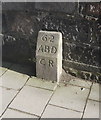
March Stone No. 62
Modest, but B-listed: http://data.historic-scotland.gov.uk/pls/htmldb/f?p=2200:15:0::::BUILDING:19961 . The march stones mark out the boundary of the medieval burgh of Aberdeen; CR stands for "city royalty."
Image: © Bill Harrison
Taken: 26 Feb 2015
0.10 miles
9
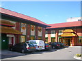
Oriental Shopping Centre, Aberdeen
This shopping centre on Causewayend includes a Chinese supermarket and restaurant
Image: © Richard Slessor
Taken: 13 Apr 2006
0.10 miles
10
King’s Crescent towards the Spital, Aberdeen
Image: © Steven Brown
Taken: 6 Apr 2024
0.11 miles