1
Looking down St Peter Street, Aberdeen
King Street in the distance, part of the bus depot on the right.
Image: © Bill Harrison
Taken: 9 Jun 2010
0.02 miles
2
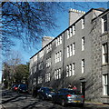
1930s Social housing, Spital, Aberdeen
Built 1934 by the Aberdeen Mother and Child Welfare Association, which was supported by Aberdeen's pioneering woman doctors Agnes Thomson and Clementina Esslemont. For the inscription over the door, see: http://www.geograph.org.uk/photo/4363258 .
Image: © Bill Harrison
Taken: 26 Feb 2015
0.02 miles
3
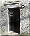
Door to 1930s social housing block
For the building, see: http://www.geograph.org.uk/photo/4363253 .
Image: © Bill Harrison
Taken: 26 Feb 2015
0.03 miles
4
Spital, Aberdeen
Looking towards Aberdeen city centre and the tower of Marischal College, after a slight dusting of snow.
Image: © Richard Sutcliffe
Taken: Unknown
0.03 miles
5
King’s Crescent towards the Spital, Aberdeen
Image: © Steven Brown
Taken: 6 Apr 2024
0.04 miles
6
Looking down Merkland Road, Aberdeen
In the distance the roof of the stand of Aberdeen FC, in the far distance, the North Sea...
Image: © Bill Harrison
Taken: 9 Jun 2010
0.05 miles
7
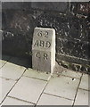
March Stone No. 62
Modest, but B-listed: http://data.historic-scotland.gov.uk/pls/htmldb/f?p=2200:15:0::::BUILDING:19961 . The march stones mark out the boundary of the medieval burgh of Aberdeen; CR stands for "city royalty."
Image: © Bill Harrison
Taken: 26 Feb 2015
0.05 miles
8
Former St Margaret's Episcopal Convent
A-listed: http://data.historic-scotland.gov.uk/pls/htmldb/f?p=2200:15:0::::BUILDING:19961. The episcopal convent closed its doors a few years ago and the complex is now, I believe, a Buddhist retreat.
Image: © Bill Harrison
Taken: 26 Feb 2015
0.06 miles
9
Granite block at the junction of King's Crescent and St Peter Street
The bottom storey was possibly once a corner shop.
Image: © Bill Harrison
Taken: 9 Jun 2010
0.06 miles
10
Looking up King's Crescent, Aberdeen
Image: © Bill Harrison
Taken: 9 Jun 2010
0.07 miles


