IMAGES TAKEN NEAR TO
Donview Place, ABERDEEN, AB24 2SG
Introduction
This page details the photographs taken nearby to Donview Place, AB24 2SG by members of the Geograph project.
The Geograph project started in 2005 with the aim of publishing, organising and preserving representative images for every square kilometre of Great Britain, Ireland and the Isle of Man.

There are currently over 7.5m images from over14,400 individuals and you can help contribute to the project by visiting https://www.geograph.org.uk
Image Map
Images are licensed for reuse under creativecommons.org/licenses/by-sa/2.0
Notes
- Clicking on the map will re-center to the selected point.
- The higher the marker number, the further away the image location is from the centre of the postcode.
Image Listing (84 Images Found)
Images are licensed for reuse under creativecommons.org/licenses/by-sa/2.0
Image
Details
Distance
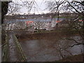
3
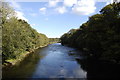
River Don
Flowing serenely as it nears the sea.
Image: © Bill Harrison
Taken: 20 Sep 2009
0.08 miles
4
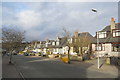
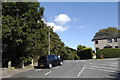
Suburban semis, Aberdeen style
A typical Aberdeen design, with large dormer windows. They are presumably granite, but all are rendered with pebbledash.
Image: © Bill Harrison
Taken: 23 Feb 2013
0.09 miles
6
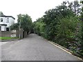
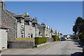
Don Terrace
Note the speed bumps, they are a useful accessory here.
Image: © Richard Webb
Taken: 3 Aug 2011
0.10 miles
7
Gordon's mills, Danestone
With footbridge over River Don.
Image: © Stanley Howe
Taken: 8 Jan 2007
0.10 miles
8
Donbank Terrace off Gordon's Mills Road, Aberdeen
Image: © Ian S
Taken: 5 Oct 2022
0.10 miles
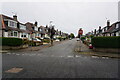
9
Granite houses, Gladstone Place, Woodside, Aberdeen
Image: © Bill Harrison
Taken: 28 Apr 2011
0.11 miles
10
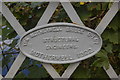
Scottish Made, and Proud of it...
Builder's plate on the bridge over the Don.
Image: © Bill Harrison
Taken: 20 Sep 2009
0.11 miles