IMAGES TAKEN NEAR TO
Great Northern Road, ABERDEEN, AB24 2BD
Introduction
This page details the photographs taken nearby to Great Northern Road, AB24 2BD by members of the Geograph project.
The Geograph project started in 2005 with the aim of publishing, organising and preserving representative images for every square kilometre of Great Britain, Ireland and the Isle of Man.

There are currently over 7.5m images from over14,400 individuals and you can help contribute to the project by visiting https://www.geograph.org.uk
Image Map
Images are licensed for reuse under creativecommons.org/licenses/by-sa/2.0
Notes
- Clicking on the map will re-center to the selected point.
- The higher the marker number, the further away the image location is from the centre of the postcode.
Image Listing (67 Images Found)
Images are licensed for reuse under creativecommons.org/licenses/by-sa/2.0
Image
Details
Distance
1
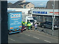
Cheap fish fingers
Discount frozen-food store on Great Northern Road.
Image: © Bill Harrison
Taken: 26 Jul 2018
0.02 miles
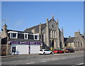
2
Former Woodside Congregational Church...
...on Great Northern Road (the A96). The building has been derelict for years and the only inhabitants are pigeons, who enter through gaping holes in the roof.
Image: © Bill Harrison
Taken: 20 Apr 2013
0.02 miles
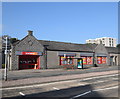
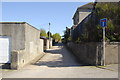
3
Sheltered housing complex, Woodside, Aberdeen
Image: © Bill Harrison
Taken: 28 Apr 2011
0.03 miles
4
Great Northern Road contrast
An ice-cream parlour and the shell of the former Woodside congregational church.
Image: © Bill Harrison
Taken: 26 Jul 2018
0.03 miles
6

View down Queen Street, Woodside, Aberdeen
Image: © Bill Harrison
Taken: 28 Apr 2011
0.05 miles
7
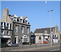
The changing face of banking
To the left, the former Clydesdale Bank, now an independent credit union; to the right, the derelict shell of the former TSB Woodside branch.
Image: © Bill Harrison
Taken: 26 Jul 2018
0.05 miles
8

Woodside Parish Church
This handsome Italianate church with tower, viewed from the south-east, was designed by Archibald Simpson in ca. 1846 and is B-listed: http://www.britishlistedbuildings.co.uk/sc-19976-woodside-parish-church-former-woodside-so . Just a few years earlier, Simpson had designed the first Woodside Parish Church (see: http://www.geograph.org.uk/photo/3424220 ), which was taken over by the Free Church after the Disruption. This was known for a while as Woodside South, until the former free church (Woodside North), just a few metres away, was converted to flats.
Image: © Bill Harrison
Taken: 20 Apr 2013
0.06 miles
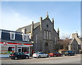
9
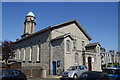
Woodside Parish Church (Church of Scotland)
Facing on to Church Street. Designed by Archibald Simpson and B-listed: http://www.britishlistedbuildings.co.uk/sc-19976-woodside-parish-church-former-woodside-so .
Image: © Bill Harrison
Taken: 28 Apr 2011
0.06 miles