IMAGES TAKEN NEAR TO
Newton Road, ABERDEEN, AB16 7YA
Introduction
This page details the photographs taken nearby to Newton Road, AB16 7YA by members of the Geograph project.
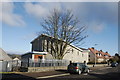
The Geograph project started in 2005 with the aim of publishing, organising and preserving representative images for every square kilometre of Great Britain, Ireland and the Isle of Man.

There are currently over 7.5m images from over14,400 individuals and you can help contribute to the project by visiting https://www.geograph.org.uk
Image Map
Images are licensed for reuse under creativecommons.org/licenses/by-sa/2.0
Notes
- Clicking on the map will re-center to the selected point.
- The higher the marker number, the further away the image location is from the centre of the postcode.
Image Listing (24 Images Found)
Images are licensed for reuse under creativecommons.org/licenses/by-sa/2.0
Image
Details
Distance
1
Manor Park Primary School, Danestone Circle, Aberdeen
As seen from Fowler Avenue. Manor Park was rebuilt with private cash as part of the "Aberdeen City 3Rs initiative" (see: http://www.partnershipsuk.org.uk/PUK-Case-Study.aspx?Region=Scotland&Project=11843 ) in order to be leased back to the city. It almost all went horribly wrong in the banking crash of 2008: http://www.eveningexpress.co.uk/Article.aspx/943673 .
Image: © Bill Harrison
Taken: 5 Jan 2013
0.08 miles
2
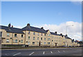
1930s Council block, Manor Avenue, Aberdeen
The twin of the block up the road (see: http://www.geograph.org.uk/photo/3344652 ) but rendered in primrose stucco.
Image: © Bill Harrison
Taken: 24 Feb 2013
0.12 miles
4
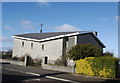
Middlefield Parish Church
View from the south-east.
Image: © Bill Harrison
Taken: 24 Feb 2013
0.14 miles
5
Middlefield Parish Church, Fowler Avenue, Aberdeen
Its postal address is Manor Avenue, which actually runs behind the building. The security fence surrounds the church hall, just visible to the left, which looks to be derelict.
Image: © Bill Harrison
Taken: 24 Feb 2013
0.14 miles
7
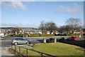
Urban green space
Across the road, the small park bordered by Logie Terrace to the left.
Image: © Bill Harrison
Taken: 24 Feb 2013
0.17 miles
8
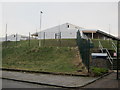
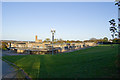
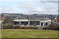
Haudagain link road
The new link road (opened 16 Nay 2022) connecting the A92 (pictured) with the A96 (behind the photographer) thereby avoiding the infamous Haudagain roundabout: a few hundred metres of road cost some £50 million. Traffic seems to be flowing freely in the first few days.
Image: © Bill Harrison
Taken: 19 May 2022
0.18 miles
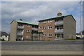
9
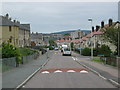
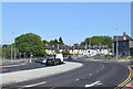
Housing estate, Cummings Park
A variety of different types of housing found in this area to the west of Anderson Drive dual carriageway. Traffic calming measures are evident to prevent people using this route as a "rat run".
Image: © Lizzie
Taken: 5 Jun 2005
0.18 miles
10
Derelict shops, Logie Place, Aberdeen
Image: © Bill Harrison
Taken: 24 Feb 2013
0.19 miles