IMAGES TAKEN NEAR TO
Davidson Place, ABERDEEN, AB16 7RD
Introduction
This page details the photographs taken nearby to Davidson Place, AB16 7RD by members of the Geograph project.
The Geograph project started in 2005 with the aim of publishing, organising and preserving representative images for every square kilometre of Great Britain, Ireland and the Isle of Man.

There are currently over 7.5m images from over14,400 individuals and you can help contribute to the project by visiting https://www.geograph.org.uk
Image Map
Images are licensed for reuse under creativecommons.org/licenses/by-sa/2.0
Notes
- Clicking on the map will re-center to the selected point.
- The higher the marker number, the further away the image location is from the centre of the postcode.
Image Listing (6 Images Found)
Images are licensed for reuse under creativecommons.org/licenses/by-sa/2.0
Image
Details
Distance
1
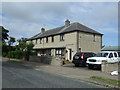
Davidson Gardens, Northfield
An unusual "dual carriageway" design for an urban street.
Image: © Bill Harrison
Taken: 8 Mar 2009
0.05 miles
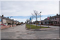
2
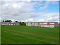
Heathryburn School (under construction)
Part of the ambitious 3Rs project in Aberdeen (see: http://www.aberdeencity.gov.uk/SchoolsColleges/rm_scc/scc_3Rs_Home.asp) Heathryburn is being built with an emphasis on sustainability and wood features prominently in the construction (http://www.aberdeencity.gov.uk/schoolscolleges/rm_scc/scc_3rs_heathryburn_school.asp?text=small).
Image: © Bill Harrison
Taken: 8 Mar 2009
0.10 miles
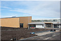
3
Westpark Primary School, Cruden Crescent, Aberdeen
Westpark Primary was previously known as Westerton Primary, but the name was changed in 2008 when it merged with Byron Park Nursery/Infant School next door. For the school website: http://www.westpark.aberdeen.sch.uk/
Image: © Bill Harrison
Taken: 5 Jan 2013
0.18 miles
4
Westpark Primary School, Northfield, Aberdeen
Formerly known as Westerton Primary School and still shown as such on most maps. It was renamed when Westerton School merged with the now-demolished Byron Park Nursery School.
Image: © Bill Harrison
Taken: 20 Sep 2014
0.20 miles
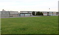
5
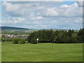
Auchmill golf club
Auchmill public golf club looking North from Northfield/Heathryfold with Bucksburn in the background.
Image: © Lizzie
Taken: 21 May 2005
0.22 miles