IMAGES TAKEN NEAR TO
Hilltop Road, ABERDEEN, AB15 9RN
Introduction
This page details the photographs taken nearby to Hilltop Road, AB15 9RN by members of the Geograph project.
The Geograph project started in 2005 with the aim of publishing, organising and preserving representative images for every square kilometre of Great Britain, Ireland and the Isle of Man.

There are currently over 7.5m images from over14,400 individuals and you can help contribute to the project by visiting https://www.geograph.org.uk
Image Map
Images are licensed for reuse under creativecommons.org/licenses/by-sa/2.0
Notes
- Clicking on the map will re-center to the selected point.
- The higher the marker number, the further away the image location is from the centre of the postcode.
Image Listing (13 Images Found)
Images are licensed for reuse under creativecommons.org/licenses/by-sa/2.0
Image
Details
Distance
6
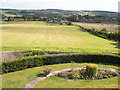
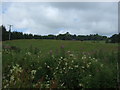
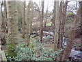
Field south of Craigton House to Cults
The field is currently under cultivation (2009) but there are plans to build houses on the land.
Image: © Ken Ross
Taken: 7 Jul 2006
0.21 miles
7
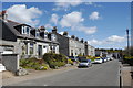
Solidly suburban
Granite terraces on Manor Place, Cults.
Image: © Bill Harrison
Taken: 12 May 2012
0.21 miles
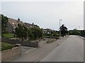
10
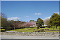
Public open space, Cults
The blossom only lasts for a couple of weeks each year...
Image: © Bill Harrison
Taken: 12 May 2012
0.24 miles