IMAGES TAKEN NEAR TO
Hilltop Road, ABERDEEN, AB15 9RL
Introduction
This page details the photographs taken nearby to Hilltop Road, AB15 9RL by members of the Geograph project.
The Geograph project started in 2005 with the aim of publishing, organising and preserving representative images for every square kilometre of Great Britain, Ireland and the Isle of Man.

There are currently over 7.5m images from over14,400 individuals and you can help contribute to the project by visiting https://www.geograph.org.uk
Image Map
Images are licensed for reuse under creativecommons.org/licenses/by-sa/2.0
Notes
- Clicking on the map will re-center to the selected point.
- The higher the marker number, the further away the image location is from the centre of the postcode.
Image Listing (6 Images Found)
Images are licensed for reuse under creativecommons.org/licenses/by-sa/2.0
Image
Details
Distance
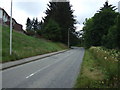
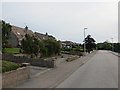
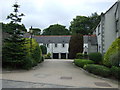
4
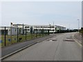
Hillview Crescent
Cults Academy - quiet at 0730 on a Sunday morning ... in the school holidays.
Image: © Richard Webb
Taken: 14 Jul 2013
0.20 miles
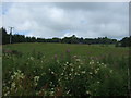
5
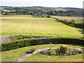
Field south of Craigton House to Cults
The field is currently under cultivation (2009) but there are plans to build houses on the land.
Image: © Ken Ross
Taken: 7 Jul 2006
0.23 miles