IMAGES TAKEN NEAR TO
Cults, ABERDEEN, AB15 9QA
Introduction
This page details the photographs taken nearby to AB15 9QA by members of the Geograph project.
The Geograph project started in 2005 with the aim of publishing, organising and preserving representative images for every square kilometre of Great Britain, Ireland and the Isle of Man.

There are currently over 7.5m images from over14,400 individuals and you can help contribute to the project by visiting https://www.geograph.org.uk
Image Map
Images are licensed for reuse under creativecommons.org/licenses/by-sa/2.0
Notes
- Clicking on the map will re-center to the selected point.
- The higher the marker number, the further away the image location is from the centre of the postcode.
Image Listing (17 Images Found)
Images are licensed for reuse under creativecommons.org/licenses/by-sa/2.0
Image
Details
Distance
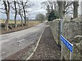
2
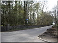
Exit from Den Wood
On to Countesswells Road at Hillhead.
Image: © Stanley Howe
Taken: 29 Apr 2010
0.04 miles
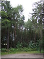
4
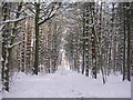
Winter snowscene at Den Wood, Countesswells
Image: © Richard Slessor
Taken: 4 Mar 2006
0.13 miles
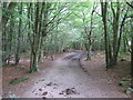
8
Minor road through Den Wood
Heading north west.
Image: © JThomas
Taken: 18 Jul 2014
0.18 miles
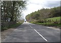
9
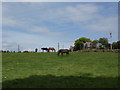
Field behind Craigton Road
The building behind is a stables and the many paths and quiet roads in this area, on the edge of the city, make it popular for equestrianism.
Image: © Alec MacKinnon
Taken: 31 May 2014
0.18 miles
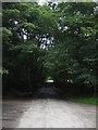
10
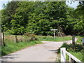
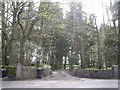
Entrance to Den Wood
Den Wood is more welcoming today than in Image
Image: © Alec MacKinnon
Taken: 31 May 2014
0.19 miles