IMAGES TAKEN NEAR TO
Bairds Brae, ABERDEEN, AB15 9PU
Introduction
This page details the photographs taken nearby to Bairds Brae, AB15 9PU by members of the Geograph project.
The Geograph project started in 2005 with the aim of publishing, organising and preserving representative images for every square kilometre of Great Britain, Ireland and the Isle of Man.

There are currently over 7.5m images from over14,400 individuals and you can help contribute to the project by visiting https://www.geograph.org.uk
Image Map
Images are licensed for reuse under creativecommons.org/licenses/by-sa/2.0
Notes
- Clicking on the map will re-center to the selected point.
- The higher the marker number, the further away the image location is from the centre of the postcode.
Image Listing (6 Images Found)
Images are licensed for reuse under creativecommons.org/licenses/by-sa/2.0
Image
Details
Distance
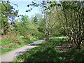
1
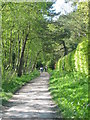
Old Deeside railway line walk, Pitfodels
Railway line from Aberdeen to Ballater closed in the 1960's now well used as a footpath and cycle way.
Image: © Lizzie
Taken: 15 May 2005
0.15 miles
2
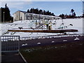
Play equipment in new estate
Woodlands hospital has been replaced by an upmarket housing estate so position is best guess.
Image: © Ewen Rennie
Taken: 1 Apr 2010
0.15 miles
3
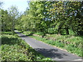
Down-line old Deeside Railway
Near Pitfodels.
Image: © Stanley Howe
Taken: 14 May 2008
0.21 miles
4
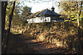
Pitfodels Station.
Station on the old Deeside Railway Line (Now the ODL walk).
Image: © Peter Ward
Taken: 9 Nov 2005
0.23 miles
5
Upline of old Deeside Railway
Near Pitfodels.
Image: © Stanley Howe
Taken: 14 May 2008
0.23 miles
6
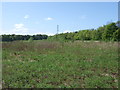
Power lines crossing barren ground at Pitfodels
Not much land like this now on Deeside so close to Aberdeen.
Image: © Stanley Howe
Taken: 14 May 2008
0.25 miles