IMAGES TAKEN NEAR TO
Inchgarth Mews, ABERDEEN, AB15 9PG
Introduction
This page details the photographs taken nearby to Inchgarth Mews, AB15 9PG by members of the Geograph project.
The Geograph project started in 2005 with the aim of publishing, organising and preserving representative images for every square kilometre of Great Britain, Ireland and the Isle of Man.

There are currently over 7.5m images from over14,400 individuals and you can help contribute to the project by visiting https://www.geograph.org.uk
Image Map
Images are licensed for reuse under creativecommons.org/licenses/by-sa/2.0
Notes
- Clicking on the map will re-center to the selected point.
- The higher the marker number, the further away the image location is from the centre of the postcode.
Image Listing (12 Images Found)
Images are licensed for reuse under creativecommons.org/licenses/by-sa/2.0
Image
Details
Distance
4
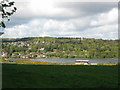
Inchgarth Reservoir, Cults, Aberdeen
Suburban settlement of Cults behind the reservoir
Image: © Lizzie
Taken: 8 May 2005
0.17 miles
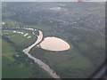
5
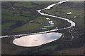
Inchgarth Reservoir, Cults, from the air
Taken from a plane heading into Aberdeen Airport. The River Dee passes the reservoir.
Image: © Mike Pennington
Taken: 30 Apr 2010
0.17 miles
6
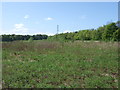
Power lines crossing barren ground at Pitfodels
Not much land like this now on Deeside so close to Aberdeen.
Image: © Stanley Howe
Taken: 14 May 2008
0.17 miles
7
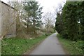
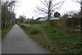
Deeside Railway, Cults
Closed in 1968 and now a cycle/footpath.
Image: © Richard Webb
Taken: 4 Apr 2017
0.18 miles
8
Cults Station
Like many stations on the Deeside Railway, the platform survives.
Image: © Richard Webb
Taken: 4 Apr 2017
0.21 miles
9
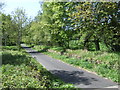
Down-line old Deeside Railway
Near Pitfodels.
Image: © Stanley Howe
Taken: 14 May 2008
0.21 miles