IMAGES TAKEN NEAR TO
North Deeside Road, ABERDEEN, AB15 9ED
Introduction
This page details the photographs taken nearby to North Deeside Road, AB15 9ED by members of the Geograph project.
The Geograph project started in 2005 with the aim of publishing, organising and preserving representative images for every square kilometre of Great Britain, Ireland and the Isle of Man.

There are currently over 7.5m images from over14,400 individuals and you can help contribute to the project by visiting https://www.geograph.org.uk
Image Map
Images are licensed for reuse under creativecommons.org/licenses/by-sa/2.0
Notes
- Clicking on the map will re-center to the selected point.
- The higher the marker number, the further away the image location is from the centre of the postcode.
Image Listing (7 Images Found)
Images are licensed for reuse under creativecommons.org/licenses/by-sa/2.0
Image
Details
Distance
1
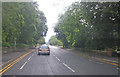
Approaching Bieldside
Photographer is above the paved northeastbound travel lane on a misty morn.
Image: © C Michael Hogan
Taken: 19 Jul 2011
0.05 miles
2
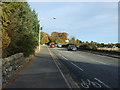
North Deeside Road (A93)
Heading east towards Aberdeen.
Image: © JThomas
Taken: 8 Nov 2013
0.11 miles
3
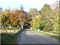
Hillhead Road, Milton of Murtle
Heading north.
Image: © JThomas
Taken: 8 Nov 2013
0.13 miles
4
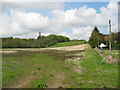
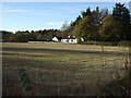
Possible route of western peripheral road
This is part of the route of the proposed Western Peripheral Road around Aberdeen. The effect on the Camphill communities has made this a very live local issue.
Image: © Lizzie
Taken: 22 May 2005
0.14 miles
5
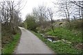
Deeside Way
Trackbed of the Deeside Railway. Much of the route is now a cycle/footpath. The usual flooded cutting problem has been well solved by the path engineers here.
Image: © Richard Webb
Taken: 4 Apr 2017
0.15 miles
7
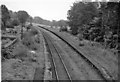
Bieldside Station (remains)
View eastwards, towards Aberdeen; Aberdeen - Ballater line; station closed 5/4/37, line closed 28/2/66 (goods 18/7/66).
Image: © Ben Brooksbank
Taken: 2 Oct 1961
0.24 miles