IMAGES TAKEN NEAR TO
Earlspark Way, ABERDEEN, AB15 9BY
Introduction
This page details the photographs taken nearby to Earlspark Way, AB15 9BY by members of the Geograph project.
The Geograph project started in 2005 with the aim of publishing, organising and preserving representative images for every square kilometre of Great Britain, Ireland and the Isle of Man.

There are currently over 7.5m images from over14,400 individuals and you can help contribute to the project by visiting https://www.geograph.org.uk
Image Map
Images are licensed for reuse under creativecommons.org/licenses/by-sa/2.0
Notes
- Clicking on the map will re-center to the selected point.
- The higher the marker number, the further away the image location is from the centre of the postcode.
Image Listing (5 Images Found)
Images are licensed for reuse under creativecommons.org/licenses/by-sa/2.0
Image
Details
Distance
1
New Cults Academy
New Cults Academy (white building) with old one (red brickbuilding) from across the River Dee
Image: © Ewen Rennie
Taken: 15 Feb 2010
0.13 miles
2
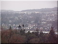
Glimpse of suburbia
Earlspark Gardens, Bieldside, Aberdeen
Image: © Bill Harrison
Taken: 12 May 2012
0.13 miles
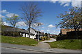
3
Baillieswells Road, Bieldside
Heading north west.
Image: © JThomas
Taken: 8 Nov 2013
0.18 miles
4
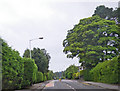
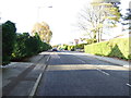
Wooded residential area along a busy street
This roadway is a well travelled route, but this scene is relatively early in the morning. Photographer is above the pavement of the northbound travel lane.
Image: © C Michael Hogan
Taken: 19 Jul 2011
0.18 miles