IMAGES TAKEN NEAR TO
Bieldside, ABERDEEN, AB15 9BQ
Introduction
This page details the photographs taken nearby to AB15 9BQ by members of the Geograph project.
The Geograph project started in 2005 with the aim of publishing, organising and preserving representative images for every square kilometre of Great Britain, Ireland and the Isle of Man.

There are currently over 7.5m images from over14,400 individuals and you can help contribute to the project by visiting https://www.geograph.org.uk
Image Map
Images are licensed for reuse under creativecommons.org/licenses/by-sa/2.0
Notes
- Clicking on the map will re-center to the selected point.
- The higher the marker number, the further away the image location is from the centre of the postcode.
Image Listing (7 Images Found)
Images are licensed for reuse under creativecommons.org/licenses/by-sa/2.0
Image
Details
Distance
1
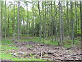
Woods by Ladyhill
Just a few minutes from the suburban area of Bieldside
Image: © Lizzie
Taken: 15 May 2005
0.09 miles
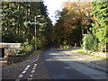
4
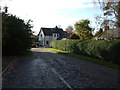
Treed residential area south of Ladyhill
Image: © C Michael Hogan
Taken: 30 Jul 2012
0.12 miles
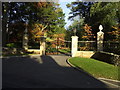
6
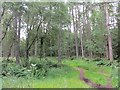
Foggieton
Woods outside Cults. Folk were about at 0730 on a Sunday morning as this is obviously a popular dog walking spot. Woods managed by the Forestry Commission.
Image: © Richard Webb
Taken: 14 Jul 2013
0.22 miles
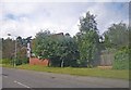
7
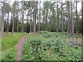
Foggieton
Woods north of Cults, this part managed by the Forestry Commission. The name is used on the Grampian Orienteers map of the area.
Image: © Richard Webb
Taken: 14 Jul 2013
0.24 miles