IMAGES TAKEN NEAR TO
Kingswells, ABERDEEN, AB15 8SS
Introduction
This page details the photographs taken nearby to AB15 8SS by members of the Geograph project.
The Geograph project started in 2005 with the aim of publishing, organising and preserving representative images for every square kilometre of Great Britain, Ireland and the Isle of Man.

There are currently over 7.5m images from over14,400 individuals and you can help contribute to the project by visiting https://www.geograph.org.uk
Image Map
Images are licensed for reuse under creativecommons.org/licenses/by-sa/2.0
Notes
- Clicking on the map will re-center to the selected point.
- The higher the marker number, the further away the image location is from the centre of the postcode.
Image Listing (12 Images Found)
Images are licensed for reuse under creativecommons.org/licenses/by-sa/2.0
Image
Details
Distance
1
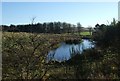
Pond by Cherrybank
Between Cherrybank and Broomfold.
Image: © Stanley Howe
Taken: 16 Nov 2007
0.08 miles
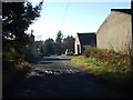
2
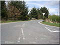
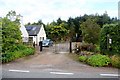
Road junction near Broomfold
Road markings appear to be ready for a third attempt to get them right!
Image: © Stanley Howe
Taken: 29 Apr 2010
0.11 miles
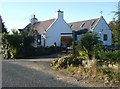
7
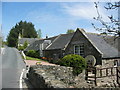
The Mill, Brotherfield
A mill cottage with beautiful garden close to the BBC Scotland Beechgrove Garden.
Image: © Lizzie
Taken: 14 May 2005
0.16 miles
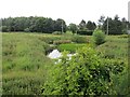
8
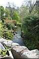
Burn at the side of Brotherfield Mill
Brodiach ? Burn
Image: © Lizzie
Taken: 14 May 2005
0.16 miles
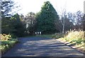
10
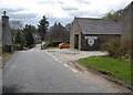
Easter Ord
Mill of Brotherfield Nursery on right.
Image: © Stanley Howe
Taken: 16 Nov 2007
0.18 miles