IMAGES TAKEN NEAR TO
Kingswells, ABERDEEN, AB15 8SL
Introduction
This page details the photographs taken nearby to AB15 8SL by members of the Geograph project.
The Geograph project started in 2005 with the aim of publishing, organising and preserving representative images for every square kilometre of Great Britain, Ireland and the Isle of Man.

There are currently over 7.5m images from over14,400 individuals and you can help contribute to the project by visiting https://www.geograph.org.uk
Image Map
Images are licensed for reuse under creativecommons.org/licenses/by-sa/2.0
Notes
- Clicking on the map will re-center to the selected point.
- The higher the marker number, the further away the image location is from the centre of the postcode.
Image Listing (11 Images Found)
Images are licensed for reuse under creativecommons.org/licenses/by-sa/2.0
Image
Details
Distance
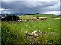
2
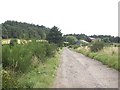
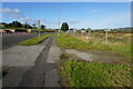
Track to Craiglug
Ben View and Lythewood ahead.
Image: © Stanley Howe
Taken: 27 Aug 2010
0.13 miles
3
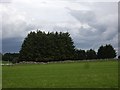
Copse off northern edge of Kingshill Wood
Image: © Stanley Howe
Taken: 27 Aug 2010
0.14 miles
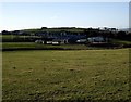
4
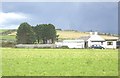
East Kingsford industrial units
Astride the A944. Seen from the minor road to East Kingsford Cottage.
Image: © Stanley Howe
Taken: 25 Sep 2014
0.18 miles
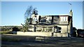
6
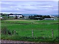
Kingsford Industrial Units
Seen from near East Kingsford Cottage.
Image: © Stanley Howe
Taken: 27 Nov 2008
0.20 miles

10
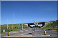
Kingswells roundabout...
...where the A944 and A90 meet along with a couple of minor roads. Note the profusion of signs, lampposts and barriers...
Image: © Bill Harrison
Taken: 30 May 2020
0.25 miles