IMAGES TAKEN NEAR TO
Kingswells, ABERDEEN, AB15 8SA
Introduction
This page details the photographs taken nearby to AB15 8SA by members of the Geograph project.
The Geograph project started in 2005 with the aim of publishing, organising and preserving representative images for every square kilometre of Great Britain, Ireland and the Isle of Man.

There are currently over 7.5m images from over14,400 individuals and you can help contribute to the project by visiting https://www.geograph.org.uk
Image Map
Images are licensed for reuse under creativecommons.org/licenses/by-sa/2.0
Notes
- Clicking on the map will re-center to the selected point.
- The higher the marker number, the further away the image location is from the centre of the postcode.
Image Listing (6 Images Found)
Images are licensed for reuse under creativecommons.org/licenses/by-sa/2.0
Image
Details
Distance
1
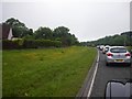
Busy afternoon traffic period as the haar is lifting
Image: © C Michael Hogan
Taken: 3 Jul 2012
0.19 miles
2
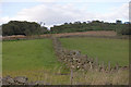
Dry stane wall
View towards the top of Cloghill, with a typical Aberdeenshire dry stane (stone) wall or dyke separating two fields in the foreground.
Image: © Bill Harrison
Taken: 1 Aug 2007
0.19 miles
4
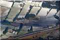
The new Aberdeen bypass at Cloghill, Kingswells, from the air
Taken from a plane on approach to Aberdeen Airport.
Image: © Mike Pennington
Taken: 24 Feb 2017
0.21 miles
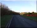
5
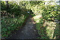
Turf Zone "GrandView"
Path leading to Fairley Road, Kingswells.
Image: © Ian S
Taken: 6 Oct 2022
0.21 miles
6
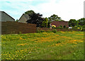
Wildflowers and homes near Farley Home Farm
Image: © C Michael Hogan
Taken: 25 Jun 2013
0.21 miles