IMAGES TAKEN NEAR TO
Kingswells, ABERDEEN, AB15 8RP
Introduction
This page details the photographs taken nearby to AB15 8RP by members of the Geograph project.
The Geograph project started in 2005 with the aim of publishing, organising and preserving representative images for every square kilometre of Great Britain, Ireland and the Isle of Man.

There are currently over 7.5m images from over14,400 individuals and you can help contribute to the project by visiting https://www.geograph.org.uk
Image Map
Images are licensed for reuse under creativecommons.org/licenses/by-sa/2.0
Notes
- Clicking on the map will re-center to the selected point.
- The higher the marker number, the further away the image location is from the centre of the postcode.
Image Listing (3 Images Found)
Images are licensed for reuse under creativecommons.org/licenses/by-sa/2.0
Image
Details
Distance
1
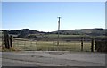
Rivehill cottages
Seen from a corner on the B979 near Concraig. The hills in the background are Elrick (left) and Brimmond (right).
Image: © Stanley Howe
Taken: 5 Mar 2009
0.04 miles
2
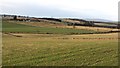
Farmland west of Elrick Hill
Looking westward from a minor road over grassland. Fields are small and divided by dykes, no doubt using stone cleared from the land.
Image: © Richard Webb
Taken: 20 Dec 2011
0.12 miles
3
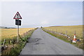
Hazard ahead
The plaque beneath the generic hazard road sign indicating a blind summit ahead has apparently been hit and twisted by a passing vehicle; after taking the photo, I bashed it back into place.
Image: © Bill Harrison
Taken: 21 Jul 2018
0.20 miles