IMAGES TAKEN NEAR TO
Kingswells, ABERDEEN, AB15 8QL
Introduction
This page details the photographs taken nearby to AB15 8QL by members of the Geograph project.
The Geograph project started in 2005 with the aim of publishing, organising and preserving representative images for every square kilometre of Great Britain, Ireland and the Isle of Man.

There are currently over 7.5m images from over14,400 individuals and you can help contribute to the project by visiting https://www.geograph.org.uk
Image Map
Images are licensed for reuse under creativecommons.org/licenses/by-sa/2.0
Notes
- Clicking on the map will re-center to the selected point.
- The higher the marker number, the further away the image location is from the centre of the postcode.
Image Listing (13 Images Found)
Images are licensed for reuse under creativecommons.org/licenses/by-sa/2.0
Image
Details
Distance

2
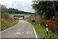
Aberdeen Western Peripheral Route crossing Countesswells Road
Image: © Alan Reid
Taken: 6 Aug 2017
0.08 miles
3
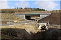
Aberdeen Western Peripheral Route (AWPR)
The bridge carries the AWPR over the Wester Ord to Blacktop road
Image: © Graeme Yuill
Taken: 20 Feb 2018
0.10 miles
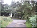
4
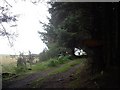
Junction of the lane from Broomhill with the public road
Image: © Stanley Howe
Taken: 27 Aug 2010
0.14 miles
5
Public road ahead
End of lane from Craiglug and Broomhill.
Image: © Stanley Howe
Taken: 27 Aug 2010
0.14 miles
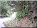
7
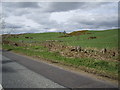
Roadside at Silverburn
Between Silverburn croft and Silverburn farm.
Image: © Stanley Howe
Taken: 29 Apr 2010
0.15 miles
8
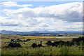
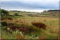
Colourful landscape looking west from Gairnhill Wood...
...with Bennachie in the distance, some 25 km away.
Image: © Bill Harrison
Taken: 26 Jul 2020
0.17 miles
10
Aberdeen Western Peripheral Route under construction
Image: © Alan Reid
Taken: 6 Aug 2017
0.22 miles