IMAGES TAKEN NEAR TO
Blacktop, ABERDEEN, AB15 8QJ
Introduction
This page details the photographs taken nearby to AB15 8QJ by members of the Geograph project.
The Geograph project started in 2005 with the aim of publishing, organising and preserving representative images for every square kilometre of Great Britain, Ireland and the Isle of Man.

There are currently over 7.5m images from over14,400 individuals and you can help contribute to the project by visiting https://www.geograph.org.uk
Image Map
Images are licensed for reuse under creativecommons.org/licenses/by-sa/2.0
Notes
- Clicking on the map will re-center to the selected point.
- The higher the marker number, the further away the image location is from the centre of the postcode.
Image Listing (11 Images Found)
Images are licensed for reuse under creativecommons.org/licenses/by-sa/2.0
Image
Details
Distance
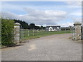
1
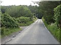
Minor road, Blacktop
In a landscape of woodland and small fields.
Image: © Richard Webb
Taken: 14 Jul 2013
0.03 miles
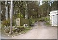
2
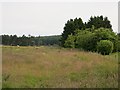
Grassland, Blacktop
Set amongst woodland.
Image: © Richard Webb
Taken: 14 Jul 2013
0.05 miles
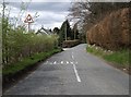
3
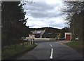
Cottage at Blacktop
By a bend in the road.
Image: © Stanley Howe
Taken: 29 Apr 2010
0.11 miles

5
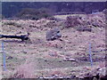
Blacktop Cup and Ring marked Stone
In the field to the West of the road going up to the house there is this cup and ring marked stone.
Image: © Ewen Rennie
Taken: 19 Feb 2006
0.17 miles
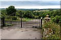
6
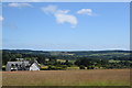
View of Treetops House and the Dee valley
Image: © Bill Harrison
Taken: 26 Jul 2020
0.17 miles