IMAGES TAKEN NEAR TO
Kingswells, ABERDEEN, AB15 8PQ
Introduction
This page details the photographs taken nearby to AB15 8PQ by members of the Geograph project.
The Geograph project started in 2005 with the aim of publishing, organising and preserving representative images for every square kilometre of Great Britain, Ireland and the Isle of Man.

There are currently over 7.5m images from over14,400 individuals and you can help contribute to the project by visiting https://www.geograph.org.uk
Image Map
Images are licensed for reuse under creativecommons.org/licenses/by-sa/2.0
Notes
- Clicking on the map will re-center to the selected point.
- The higher the marker number, the further away the image location is from the centre of the postcode.
Image Listing (12 Images Found)
Images are licensed for reuse under creativecommons.org/licenses/by-sa/2.0
Image
Details
Distance
1
A glimpse of Newpark House
It has a Canmore record (347805: https://canmore.org.uk/site/347805/newpark-house ) but there is not much to say.
Image: © Bill Harrison
Taken: 22 May 2020
0.03 miles
2
A glimpse of Newpark House
The tree-lined drive appears to be out of use and the house is accessed from a back-road.
Image: © Bill Harrison
Taken: 22 May 2020
0.03 miles
3
Newpark House, near Kingswells
Farmhouse on the edge of Aberdeen.
Image: © Richard Slessor
Taken: 30 Dec 2006
0.07 miles
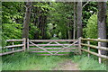
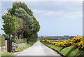
4
Track near Fernhill, Aberdeen, Scotland
A countryside track near to Fernhill on the west side of the city of Aberdeen, Scotland, UK
Image: © Andrew Tryon
Taken: 19 Aug 2019
0.11 miles
5
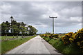
Looking eastwards along the Old Lang Stracht
This was once the busy A944 road to Alford and points west, but it has been bypassed by a new alignment to the south.
Image: © Bill Harrison
Taken: 22 May 2020
0.15 miles
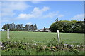
6
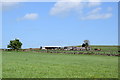
View across the fields to Fernhill Farm
The farm is actually within the boundary of the City of Aberdeen.
Image: © Bill Harrison
Taken: 22 May 2020
0.15 miles
7
Exercising in the time of coronavirus (May 2020)
The blown-up photo shows numerous people walking along the Old Lang Stracht in May 2020. The exit in the foreground is for buses only, so the road is very quiet (note the enforcement camera to the right of the left-hand speed limit sign).
Image: © Bill Harrison
Taken: 22 May 2020
0.18 miles
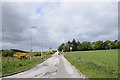
8
The Old Lang Stracht, looking eastwards...
...with the beginning of the Aberdeen western suburbs in the distance.
Image: © Bill Harrison
Taken: 22 May 2020
0.18 miles
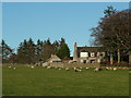
9
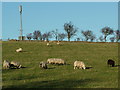
Sheep Grazing near Kingswells
This is the outskirts of Aberdeen City close to the dormitory settlement/suburb of Kingswells.
Image: © Richard Slessor
Taken: 30 Dec 2006
0.20 miles
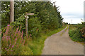
10
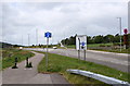
New and old courses of the A944
The A944 now sweeps to the left to head to the south of Kingswells. The old road, which is guarded by a bus gate, can be seen climbing the hill to the right.
Image: © Bill Harrison
Taken: 22 May 2020
0.22 miles