IMAGES TAKEN NEAR TO
Woodburn Crescent, ABERDEEN, AB15 8JX
Introduction
This page details the photographs taken nearby to Woodburn Crescent, AB15 8JX by members of the Geograph project.
The Geograph project started in 2005 with the aim of publishing, organising and preserving representative images for every square kilometre of Great Britain, Ireland and the Isle of Man.

There are currently over 7.5m images from over14,400 individuals and you can help contribute to the project by visiting https://www.geograph.org.uk
Image Map
Images are licensed for reuse under creativecommons.org/licenses/by-sa/2.0
Notes
- Clicking on the map will re-center to the selected point.
- The higher the marker number, the further away the image location is from the centre of the postcode.
Image Listing (21 Images Found)
Images are licensed for reuse under creativecommons.org/licenses/by-sa/2.0
Image
Details
Distance
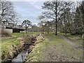
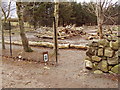
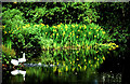
2
Stream and path
Link between Craigiebuckler and Hazlehead
Image: © Ewen Rennie
Taken: 4 Apr 2010
0.07 miles
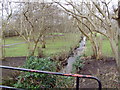
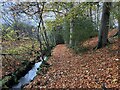
5
Linking footpath
Joint venture between Aberdeen Greenspace and the City Council.
Image: © Ewen Rennie
Taken: 4 Apr 2010
0.13 miles
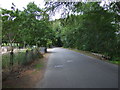
8
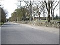
Access road to Hazlehead Park
With a whole bevy of pink sleeping policemen lying in wait!
Image: © Stanley Howe
Taken: 29 Apr 2010
0.22 miles
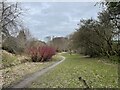
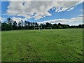
10
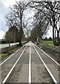
Hazlehead Running Track
Multi-user running track leading to Hazlehead Park
Image: © David Robinson
Taken: 4 Apr 2024
0.22 miles