IMAGES TAKEN NEAR TO
Woodburn Gardens, ABERDEEN, AB15 8JA
Introduction
This page details the photographs taken nearby to Woodburn Gardens, AB15 8JA by members of the Geograph project.
The Geograph project started in 2005 with the aim of publishing, organising and preserving representative images for every square kilometre of Great Britain, Ireland and the Isle of Man.

There are currently over 7.5m images from over14,400 individuals and you can help contribute to the project by visiting https://www.geograph.org.uk
Image Map
Images are licensed for reuse under creativecommons.org/licenses/by-sa/2.0
Notes
- Clicking on the map will re-center to the selected point.
- The higher the marker number, the further away the image location is from the centre of the postcode.
Image Listing (29 Images Found)
Images are licensed for reuse under creativecommons.org/licenses/by-sa/2.0
Image
Details
Distance
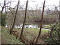
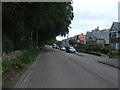
3
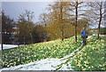
Walker Dam, Aberdeen
Walker Dam, off Springfield Road, with daffodils under spring snow.
Image: © Colin Smith
Taken: Unknown
0.09 miles
10
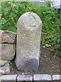
Old Milestone by the B9119, Queen's Road
Aberdeen granite by the B9119, in parish of Aberdeen (Aberdeen City), junction with Hazelhead Road, in acute corner.
Surveyed
Milestone Society National ID: CA_ADAL02.
Image: © Milestone Society
Taken: Unknown
0.12 miles