IMAGES TAKEN NEAR TO
Brooke Drive, ABERDEEN, AB15 8AW
Introduction
This page details the photographs taken nearby to Brooke Drive, AB15 8AW by members of the Geograph project.
The Geograph project started in 2005 with the aim of publishing, organising and preserving representative images for every square kilometre of Great Britain, Ireland and the Isle of Man.

There are currently over 7.5m images from over14,400 individuals and you can help contribute to the project by visiting https://www.geograph.org.uk
Image Map
Images are licensed for reuse under creativecommons.org/licenses/by-sa/2.0
Notes
- Clicking on the map will re-center to the selected point.
- The higher the marker number, the further away the image location is from the centre of the postcode.
Image Listing (23 Images Found)
Images are licensed for reuse under creativecommons.org/licenses/by-sa/2.0
Image
Details
Distance
1
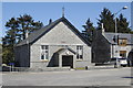
Kingswells Church Hall
The inscription above the door reads: This stone was laid / by / Captain Brooke / of Fairley / on 24th August 1901.
Image: © Bill Harrison
Taken: 30 Apr 2011
0.05 miles
2
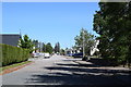
Looking along Old Skene Road, Kingswells
The church hall is visible beyond the hedge to the left.
Image: © Bill Harrison
Taken: 30 May 2020
0.05 miles
3
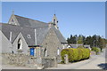
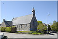
Kingswells Parish Church (Church of Scotland)
Image: © Bill Harrison
Taken: 30 Apr 2011
0.07 miles
4
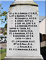
Kingswells war memorial (close-up of west elevation)
Image: © Bill Harrison
Taken: 30 May 2020
0.07 miles
5
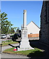
Kingswells war memorial...
...located just north of the parish kirk.
Image: © Bill Harrison
Taken: 30 May 2020
0.07 miles
6
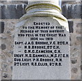
Kingswells war memorial (close-up of north elevation)
The north face of the memorial lists officers, while the east and west faces list the 'men' who fell. Notable names are James Brooke VC (https://en.wikipedia.org/wiki/James_Anson_Otho_Brooke ) who was killed in action at Ypres in 1914 and his brother Henry Brooke who died in London in 1916 after being mortally wounded at the Somme.
Image: © Bill Harrison
Taken: 30 May 2020
0.07 miles
7
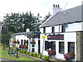
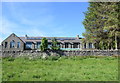
Four Mile House
Upmarket pub and restaurant on the Old Skene Road. It lies between Woodend and Kingswells, affluent Aberdeen suburbs.
Image: © Colin Smith
Taken: 7 Aug 2009
0.07 miles
8
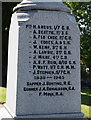
Kingswells war memorial (close-up of east elevation)
Image: © Bill Harrison
Taken: 30 May 2020
0.08 miles
9
Kingswells Parish Church
View from Old Skeke Road. The building style is called "polygonal ragwork," see: http://www.kingswells.com/HISTORY/tabid/457/Default.aspx
Image: © Bill Harrison
Taken: 30 Apr 2011
0.08 miles
10
Former Kingswells School
Built 1932. When Geographer Lizzie photographed it in 2005 it was the nursery and infant school (https://www.geograph.org.uk/photo/11449 ) but it now serves as a council-run 'outdoor adventure centre', which, according to the Aberdeen City Council website, serves school groups as well as stag and hen parties.
Image: © Bill Harrison
Taken: 30 May 2020
0.09 miles