IMAGES TAKEN NEAR TO
Thorngrove Avenue, ABERDEEN, AB15 7XR
Introduction
This page details the photographs taken nearby to Thorngrove Avenue, AB15 7XR by members of the Geograph project.
The Geograph project started in 2005 with the aim of publishing, organising and preserving representative images for every square kilometre of Great Britain, Ireland and the Isle of Man.

There are currently over 7.5m images from over14,400 individuals and you can help contribute to the project by visiting https://www.geograph.org.uk
Image Map
Images are licensed for reuse under creativecommons.org/licenses/by-sa/2.0
Notes
- Clicking on the map will re-center to the selected point.
- The higher the marker number, the further away the image location is from the centre of the postcode.
Image Listing (29 Images Found)
Images are licensed for reuse under creativecommons.org/licenses/by-sa/2.0
Image
Details
Distance
1
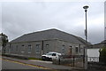
Telephone exchange, Thorngrove Avenue, Aberdeen
A date-stone on the other side of the building reads 1936 and has the GPO logo. As has been said many times before, Aberdeen granite sparkles in the sunshine, but can look a little dour under cloudy skies...
Image: © Bill Harrison
Taken: 8 Oct 2011
0.09 miles
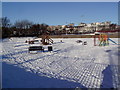
3
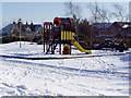
Thorngrove kiddies play area
This is one of seven children's playgrounds in the West End of Aberdeen that I visited in the course of an eighty minute dog walk. A sign nearby says that it and surrounding landscaped area is maintained by residents of the mini-estate which was built on the former site of the RGU school playing fields.
The seven are Rubislaw, Kepplestone, Johnston Gardens, Craigiebuckler, Airyhall, Craigielea and Thorngrove.
Image: © Ewen Rennie
Taken: 21 Feb 2010
0.12 miles
4
Playground in Rubislaw playing fields
This is one of seven children's playgrounds in the West End of Aberdeen that I visited in the course of an eighty minute dog walk. The others are mainly for younger children.
The seven are Rubislaw, Kepplestone, Johnston Gardens, Craigiebuckler, Airyhall, Craigielea and Thorngrove.
Image: © Ewen Rennie
Taken: 21 Feb 2010
0.17 miles
5
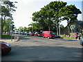
Anderson Drive
At the junction with Great Western Road (A93), this 4 lane road carries all the traffic travelling north - south trying to avoid Aberdeen city centre.
Image: © Lizzie
Taken: 6 Jun 2005
0.17 miles
6
Western Cross
Western Cross-new development of flats on the site of the former Amatola Hotel close to the junction of Anderson Drive & Great Western Road.
Image: © Lizzie
Taken: 6 Jun 2005
0.17 miles
7
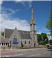
Mannofield Kirk
Built 1882 and still active.
Image: © Bill Harrison
Taken: 2 Jun 2013
0.18 miles
8
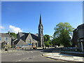
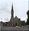
Mannofield Church
Mannofield Church and its tall spire from the junction with Cranford Road to the south.
Image: © Scott Cormie
Taken: 21 May 2022
0.18 miles
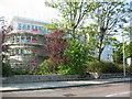
9
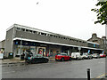
Shops on Great Western Road, Aberdeen
As of 2019 the row included Boots pharmacy, an opticians, solicitors and a Co-Op store.
Image: © Stephen Craven
Taken: 4 Jul 2019
0.18 miles