IMAGES TAKEN NEAR TO
Viewfield Road, ABERDEEN, AB15 7XL
Introduction
This page details the photographs taken nearby to Viewfield Road, AB15 7XL by members of the Geograph project.
The Geograph project started in 2005 with the aim of publishing, organising and preserving representative images for every square kilometre of Great Britain, Ireland and the Isle of Man.

There are currently over 7.5m images from over14,400 individuals and you can help contribute to the project by visiting https://www.geograph.org.uk
Image Map
Images are licensed for reuse under creativecommons.org/licenses/by-sa/2.0
Notes
- Clicking on the map will re-center to the selected point.
- The higher the marker number, the further away the image location is from the centre of the postcode.
Image Listing (161 Images Found)
Images are licensed for reuse under creativecommons.org/licenses/by-sa/2.0
Image
Details
Distance
2
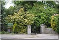
Entrance to Johnston Gardens
From Viewfield Road.
Image: © Stanley Howe
Taken: 28 May 2009
0.01 miles
3
Boundary fence of Johnston Gardens
By Viewfield Road.
Image: © Stanley Howe
Taken: 28 May 2009
0.02 miles
4
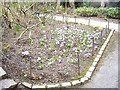
Crocus bed
In Johnston Gardens, Aberdeen.
Image: © Stanley Howe
Taken: 24 Mar 2011
0.03 miles
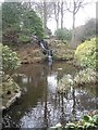
5
Downstream West Burn of Rubislaw
From a footbridge in Johnston Gardens.
Image: © Stanley Howe
Taken: 24 Mar 2011
0.03 miles
6
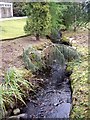
Dense waterside foliage
At the east end outflow from the lochan in Johnston Gardens.
Image: © Stanley Howe
Taken: 3 Aug 2017
0.03 miles
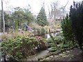
7
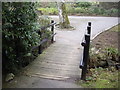
A footbridge over West Burn of Rubislaw
At the east end of the pool in Johnston Gardens.
Image: © Stanley Howe
Taken: 24 Mar 2011
0.03 miles
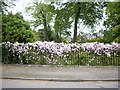
10
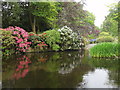
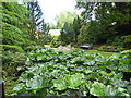
Johnston Gardens - Aberdeen
Rhododendrons in Johnston Gardens, May, 2011.
Image: © Gillian Thomas
Taken: 29 May 2011
0.04 miles