IMAGES TAKEN NEAR TO
Viewfield Road, ABERDEEN, AB15 7XE
Introduction
This page details the photographs taken nearby to Viewfield Road, AB15 7XE by members of the Geograph project.
The Geograph project started in 2005 with the aim of publishing, organising and preserving representative images for every square kilometre of Great Britain, Ireland and the Isle of Man.

There are currently over 7.5m images from over14,400 individuals and you can help contribute to the project by visiting https://www.geograph.org.uk
Image Map
Images are licensed for reuse under creativecommons.org/licenses/by-sa/2.0
Notes
- Clicking on the map will re-center to the selected point.
- The higher the marker number, the further away the image location is from the centre of the postcode.
Image Listing (160 Images Found)
Images are licensed for reuse under creativecommons.org/licenses/by-sa/2.0
Image
Details
Distance
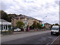
1
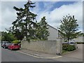
Viewfield Road, Rubislaw, Aberdeen
Dwellings at the north end.
Image: © Stanley Howe
Taken: 20 Jun 2017
0.00 miles
2
North end of Viewfield Road
From its junction with Queen's Road (B9119).
Image: © Stanley Howe
Taken: 25 Sep 2014
0.01 miles
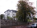
3
New flats
New flats built on site of former filling station
Image: © Ewen Rennie
Taken: 12 Oct 2010
0.01 miles

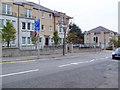
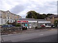
6
Flats on Queen's Road
Handy for a hair dresser, a bus stop, and a telephone box.
Image: © Stanley Howe
Taken: 25 Sep 2014
0.04 miles
8
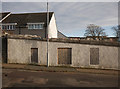
Windows in the wall, Viewfield Road
It seems this wall was part of Kepplestone Mansion and farmhouse. It was part of Robert Gordon University for a few years. It was demolished in 2016, after it was damaged by a fire.
The site has now been developed into housing.
Image: © Craig Wallace
Taken: 19 Jan 2020
0.06 miles
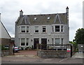
9
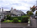
Dwellings on Queen's Road
Between Viewfield Road and Rubislaw Park Road.
Image: © Stanley Howe
Taken: 25 Sep 2014
0.06 miles
10
Hill of Rubislaw
Looking east from the junction of Rubislaw Park Road with Queen's Road (B9119).
Image: © Stanley Howe
Taken: 2 Jun 2011
0.06 miles