IMAGES TAKEN NEAR TO
Springfield Place, ABERDEEN, AB15 7SF
Introduction
This page details the photographs taken nearby to Springfield Place, AB15 7SF by members of the Geograph project.
The Geograph project started in 2005 with the aim of publishing, organising and preserving representative images for every square kilometre of Great Britain, Ireland and the Isle of Man.

There are currently over 7.5m images from over14,400 individuals and you can help contribute to the project by visiting https://www.geograph.org.uk
Image Map
Images are licensed for reuse under creativecommons.org/licenses/by-sa/2.0
Notes
- Clicking on the map will re-center to the selected point.
- The higher the marker number, the further away the image location is from the centre of the postcode.
Image Listing (123 Images Found)
Images are licensed for reuse under creativecommons.org/licenses/by-sa/2.0
Image
Details
Distance
1
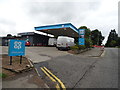
Service station on Springfield Road, Aberdeen
Image: © JThomas
Taken: 26 Aug 2020
0.09 miles
2
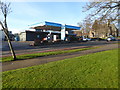
Co-op filling station on Springfield Road
Seen from the west end of Rubislaw Park Road.
Image: © Stanley Howe
Taken: 21 Dec 2017
0.10 miles
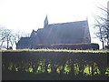
6
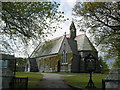
Craigiebuckler Church, Aberdeen
A beautiful setting very popular for weddings.
Image: © Lizzie
Taken: 15 May 2005
0.12 miles
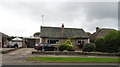
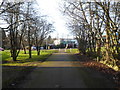
8
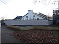
Care Home on Rubislaw Park Road
Seen from the west end access path from Springfield Road.
Image: © Stanley Howe
Taken: 21 Dec 2017
0.12 miles
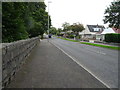
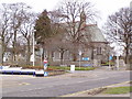
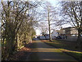
9
West end of Rubislaw Park Road
Pedestrian/cycle pathway beyond barrier poles affords access to Springfield Road.
Image: © Stanley Howe
Taken: 21 Dec 2017
0.12 miles
10
Pedestrian/Cycle access to Rubislaw Park Road
From Springfield Road.
Image: © Stanley Howe
Taken: 21 Dec 2017
0.12 miles