IMAGES TAKEN NEAR TO
St. Margarets Place, ABERDEEN, AB15 6GA
Introduction
This page details the photographs taken nearby to St. Margarets Place, AB15 6GA by members of the Geograph project.
The Geograph project started in 2005 with the aim of publishing, organising and preserving representative images for every square kilometre of Great Britain, Ireland and the Isle of Man.

There are currently over 7.5m images from over14,400 individuals and you can help contribute to the project by visiting https://www.geograph.org.uk
Image Map
Images are licensed for reuse under creativecommons.org/licenses/by-sa/2.0
Notes
- Clicking on the map will re-center to the selected point.
- The higher the marker number, the further away the image location is from the centre of the postcode.
Image Listing (22 Images Found)
Images are licensed for reuse under creativecommons.org/licenses/by-sa/2.0
Image
Details
Distance
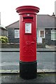
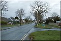
3
King's Gate junction with Ord Street
A closer view of the postbox can be seen here: Image
Image: © Mark Anderson
Taken: 25 Jan 2019
0.14 miles
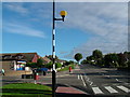
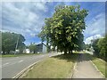
5
Summerhill Road junction with Rosewell Terrace
Image: © Mark Anderson
Taken: 25 Jan 2019
0.15 miles
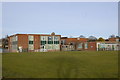
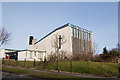
7
Summerhill Parish Church
A modern building on Stronsay Drive; opposite Fernlea Crescent.
Image: © Stanley Howe
Taken: 28 May 2009
0.16 miles
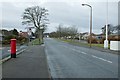
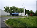
9
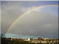
Rainbow over Summerhill
The ugly 1960s Summerhill Church can be seen as well as suburban houses on Stronsay Drive.
Image: © Richard Slessor
Taken: 18 Nov 2003
0.18 miles