IMAGES TAKEN NEAR TO
Gray Court, ABERDEEN, AB15 6EZ
Introduction
This page details the photographs taken nearby to Gray Court, AB15 6EZ by members of the Geograph project.
The Geograph project started in 2005 with the aim of publishing, organising and preserving representative images for every square kilometre of Great Britain, Ireland and the Isle of Man.

There are currently over 7.5m images from over14,400 individuals and you can help contribute to the project by visiting https://www.geograph.org.uk
Image Map
Images are licensed for reuse under creativecommons.org/licenses/by-sa/2.0
Notes
- Clicking on the map will re-center to the selected point.
- The higher the marker number, the further away the image location is from the centre of the postcode.
Image Listing (25 Images Found)
Images are licensed for reuse under creativecommons.org/licenses/by-sa/2.0
Image
Details
Distance
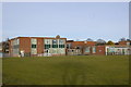
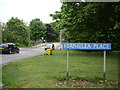
1
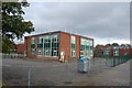
Summerhill Education Centre
Formerly a secondary school and then council offices and now semi derelict.
Image: © Bill Harrison
Taken: 5 Feb 2011
0.06 miles
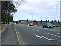
4
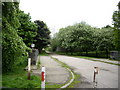
View southwards from Ferniehill Place
Bridge over North Burn of Rubislaw in mid picture.
Image: © Stanley Howe
Taken: 28 May 2009
0.14 miles
6
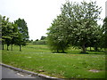
Green space by Fernlea Crescent
With North Burn of Rubislaw running through it.
Image: © Stanley Howe
Taken: 28 May 2009
0.14 miles
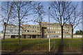
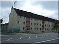
8
Fernielea Primary School, Stronsay Drive, Aberdeen
Image: © Bill Harrison
Taken: 5 Oct 2014
0.15 miles
9
Bridge over North Burn of Rubislaw
Fernielea Lane.
Image: © Stanley Howe
Taken: 28 May 2009
0.16 miles