IMAGES TAKEN NEAR TO
Auskerry Avenue, ABERDEEN, AB15 6BD
Introduction
This page details the photographs taken nearby to Auskerry Avenue, AB15 6BD by members of the Geograph project.
The Geograph project started in 2005 with the aim of publishing, organising and preserving representative images for every square kilometre of Great Britain, Ireland and the Isle of Man.

There are currently over 7.5m images from over14,400 individuals and you can help contribute to the project by visiting https://www.geograph.org.uk
Image Map
Images are licensed for reuse under creativecommons.org/licenses/by-sa/2.0
Notes
- Clicking on the map will re-center to the selected point.
- The higher the marker number, the further away the image location is from the centre of the postcode.
Image Listing (23 Images Found)
Images are licensed for reuse under creativecommons.org/licenses/by-sa/2.0
Image
Details
Distance
1
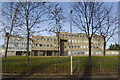
Summerhill Education Centre
Formerly a secondary school and then council offices and now semi derelict.
Image: © Bill Harrison
Taken: 5 Feb 2011
0.04 miles
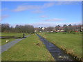
6

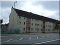
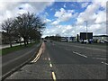
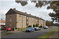
Looking east on a residential street.
The structures are all multi-family apartment buildings
Image: © C Michael Hogan
Taken: 17 Jul 2009
0.15 miles
8
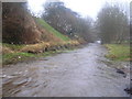
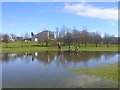
Denburn in spate (Summerhill)
This is normally a slow moving trickle of a burn.
Image: © Richard Slessor
Taken: 25 Mar 2006
0.17 miles
9
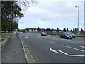
Denburn at High Level
The Denburn is beginning to return to normal level after the heavy rain of the previous day.
Image: © Richard Slessor
Taken: 26 Mar 2006
0.17 miles