IMAGES TAKEN NEAR TO
Raeden Place, ABERDEEN, AB15 5WN
Introduction
This page details the photographs taken nearby to Raeden Place, AB15 5WN by members of the Geograph project.
The Geograph project started in 2005 with the aim of publishing, organising and preserving representative images for every square kilometre of Great Britain, Ireland and the Isle of Man.

There are currently over 7.5m images from over14,400 individuals and you can help contribute to the project by visiting https://www.geograph.org.uk
Image Map
Images are licensed for reuse under creativecommons.org/licenses/by-sa/2.0
Notes
- Clicking on the map will re-center to the selected point.
- The higher the marker number, the further away the image location is from the centre of the postcode.
Image Listing (29 Images Found)
Images are licensed for reuse under creativecommons.org/licenses/by-sa/2.0
Image
Details
Distance
1
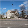
Sheltered housing, North Anderson Drive, Aberdeen
Image: © Bill Harrison
Taken: 4 May 2013
0.02 miles
2
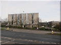
Woodhill House
This was built in the 1970s brutalist style as the headquarters of the now defunct Grampian Regional Council (1975-1996), which fragmented into Aberdeen City Council, Aberdeenshire Council (who still occupy the building) and Moray Council.
Image: © Bill Harrison
Taken: 5 Jan 2013
0.05 miles
3
Red light for southbound Anderson Drive traffic
Image: © C Michael Hogan
Taken: 5 Jun 2010
0.05 miles
4
Woodhill House, Aberdeen
The headquarters of Aberdeenshire Council is a fine example of brutalist architecture.
Image: © Bill Harrison
Taken: 4 May 2013
0.05 miles
5
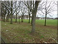
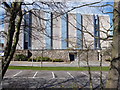
Open space...
...beside the A90 and Mid Stocket Road, looking a little bleak on a winter day. What I believe are sheltered housing units are in the background.
Image: © Bill Harrison
Taken: 31 Dec 2012
0.05 miles
6
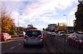
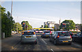
Junction of A-roads on Aberdeen ring road.
Traffic lights where A944 crosses A90.
Image: © Stanley Howe
Taken: 13 Nov 2015
0.06 miles
7
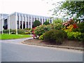
Woodhill House, Westburn Road
Aberdeenshire Council Headquarters
Image: © Colin Walker
Taken: 1 Jun 2005
0.07 miles
8
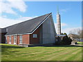
Church of Jesus Christ of Latter Day Saints, Aberdeen
Mormon church at the junction of North Anderson Drive and the Lang Stracht; built ca. 1958.
Image: © Bill Harrison
Taken: 4 May 2013
0.07 miles
9
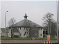
The Cocked Hat, Anderson Drive, Aberdeen
Next to Premier hotel.
Image: © JThomas
Taken: 25 Apr 2010
0.13 miles
10
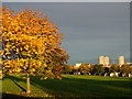
Autumn Colour at Midstocket
This area of open land lies between Midstocket Road and Westburn Road. The tower blocks at Stockethill loom in the background.
Image: © Richard Slessor
Taken: 7 Nov 2006
0.13 miles