IMAGES TAKEN NEAR TO
Camperdown Road, ABERDEEN, AB15 5NW
Introduction
This page details the photographs taken nearby to Camperdown Road, AB15 5NW by members of the Geograph project.
The Geograph project started in 2005 with the aim of publishing, organising and preserving representative images for every square kilometre of Great Britain, Ireland and the Isle of Man.

There are currently over 7.5m images from over14,400 individuals and you can help contribute to the project by visiting https://www.geograph.org.uk
Image Map
Images are licensed for reuse under creativecommons.org/licenses/by-sa/2.0
Notes
- Clicking on the map will re-center to the selected point.
- The higher the marker number, the further away the image location is from the centre of the postcode.
Image Listing (40 Images Found)
Images are licensed for reuse under creativecommons.org/licenses/by-sa/2.0
Image
Details
Distance
1
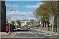
Looking down Harcourt Road
Major construction work at Forresterhill hospital complex in the distance.
Image: © Bill Harrison
Taken: 12 Apr 2011
0.06 miles
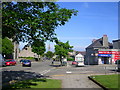
2
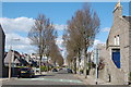
Looking down Camperdown Road, Aberdeen
Image: © Bill Harrison
Taken: 12 Apr 2011
0.06 miles
3
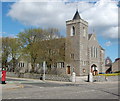
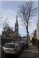
Midstocket Kirk
Church of Scotland: this forward-looking church has its own website: http://www.midstocketchurch.org.uk/. Harcourt Road heads off to the left; in the foreground Mid Stocket Road. The church, built in 1900, is dedicated to St Ninian and B-listed: http://www.britishlistedbuildings.co.uk/sc-19971-mid-stocket-road-st-ninian-s-church-churc .
Image: © Bill Harrison
Taken: 12 Apr 2011
0.08 miles
4
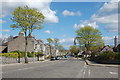
Mid Stocket Road, Aberdeen
The spire of Beechgrove Church is visible in the distance.
Image: © Bill Harrison
Taken: 12 Apr 2011
0.09 miles
5
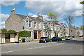
Granite Terrace, Mid Stocket Road
Utterly typical housing in the "West End" of Aberdeen.
Image: © Bill Harrison
Taken: 12 Apr 2011
0.10 miles
6
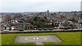
The helipad at Foresterhill Health Campus, Aberdeen
Image: © Mike Pennington
Taken: 8 Feb 2017
0.11 miles
7
View up Mid Stocket Road, Aberdeen
The disused hulk of Beechgrove Church is prominent on the left-hand side of the street.
Image: © Bill Harrison
Taken: 26 Feb 2012
0.11 miles
8
Heliport at Aberdeen Royal Infirmary
Image: © Richard Slessor
Taken: 23 Jan 2007
0.11 miles
9
Midstocket Road, Aberdeen
This road runs for about a mile from Mile End to North Anderson Drive. Most of the housing in the vicinity dates from the early 20th Century.
Image: © Richard Slessor
Taken: 12 Jun 2006
0.11 miles
10
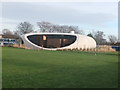
Maggie's Centre, Aberdeen Royal Infirmary
A support centre for cancer patients named after Maggie Jencks: https://www.maggiescentres.org/our-centres/maggies-aberdeen/ .
Image: © Bill Harrison
Taken: 13 Dec 2014
0.13 miles