IMAGES TAKEN NEAR TO
Richmondhill Place, ABERDEEN, AB15 5FA
Introduction
This page details the photographs taken nearby to Richmondhill Place, AB15 5FA by members of the Geograph project.
The Geograph project started in 2005 with the aim of publishing, organising and preserving representative images for every square kilometre of Great Britain, Ireland and the Isle of Man.

There are currently over 7.5m images from over14,400 individuals and you can help contribute to the project by visiting https://www.geograph.org.uk
Image Map
Images are licensed for reuse under creativecommons.org/licenses/by-sa/2.0
Notes
- Clicking on the map will re-center to the selected point.
- The higher the marker number, the further away the image location is from the centre of the postcode.
Image Listing (51 Images Found)
Images are licensed for reuse under creativecommons.org/licenses/by-sa/2.0
Image
Details
Distance
1
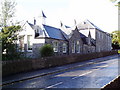
Flats on Kings Gate
The former Northsound Radio base now turned into flats. Before Northsound took it over it housed Kingslea Special School.
Image: © Ewen Rennie
Taken: 15 Sep 2010
0.07 miles
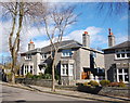
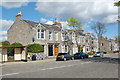
2
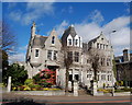
The Atholl Hotel, 54 King's Gate, Aberdeen
This B-listed building (see: http://www.britishlistedbuildings.co.uk/sc-20413-54-king-s-gate-atholl-hotel-including-gat ) is thought to have begun life as a Scottish Baronial-style house. The east extension with its delicate granite-work tracery and pinnacles is said to have been a "dry run" for the façade of Marischal College.
Image: © Bill Harrison
Taken: 16 Mar 2014
0.08 miles
3
Hamilton Place, Aberdeen
The block to the west of Fountainhall Road with typical granite villas.
Image: © Bill Harrison
Taken: 16 Mar 2014
0.09 miles
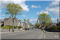
4
Looking up Forest Road, Aberdeen
At the top of the hill (the junction with King's Gate) can be seen the Atholl Hotel.
Image: © Bill Harrison
Taken: 16 Mar 2014
0.09 miles
6
Granite terrace, Gordondale Road, Aberdeen
Image: © Bill Harrison
Taken: 12 Apr 2011
0.11 miles
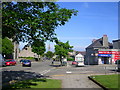
7
Morningfield Road junction with Forest Road
Image: © Mark Anderson
Taken: 25 Jan 2019
0.13 miles
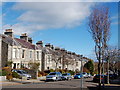
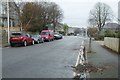
8
Midstocket Road, Aberdeen
This road runs for about a mile from Mile End to North Anderson Drive. Most of the housing in the vicinity dates from the early 20th Century.
Image: © Richard Slessor
Taken: 12 Jun 2006
0.13 miles
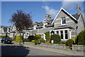
9
Granite Terrace, Mid Stocket Road
Utterly typical housing in the "West End" of Aberdeen.
Image: © Bill Harrison
Taken: 12 Apr 2011
0.14 miles
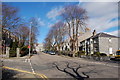
10
Mid Stocket Road, Aberdeen
The spire of Beechgrove Church is visible in the distance.
Image: © Bill Harrison
Taken: 12 Apr 2011
0.14 miles