IMAGES TAKEN NEAR TO
Forest Avenue, ABERDEEN, AB15 4UU
Introduction
This page details the photographs taken nearby to Forest Avenue, AB15 4UU by members of the Geograph project.
The Geograph project started in 2005 with the aim of publishing, organising and preserving representative images for every square kilometre of Great Britain, Ireland and the Isle of Man.

There are currently over 7.5m images from over14,400 individuals and you can help contribute to the project by visiting https://www.geograph.org.uk
Image Map
Images are licensed for reuse under creativecommons.org/licenses/by-sa/2.0
Notes
- Clicking on the map will re-center to the selected point.
- The higher the marker number, the further away the image location is from the centre of the postcode.
Image Listing (74 Images Found)
Images are licensed for reuse under creativecommons.org/licenses/by-sa/2.0
Image
Details
Distance
1
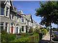
Gladstone Place, Aberdeen
These granite houses on Gladstone Place are typical of those found throughout the Grid Square.
Image: © Richard Slessor
Taken: 16 Jun 2003
0.04 miles
2
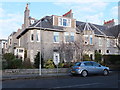
Granite corner block...
...at Gladstone Place, Aberdeen
Image: © Bill Harrison
Taken: 29 Dec 2013
0.05 miles
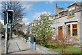
4
Harlaw Road, Aberdeen
A tree-lined street approaching the Grammar School playing ground pavilion (ahead left).
Image: © Stanley Howe
Taken: 3 Aug 2017
0.07 miles
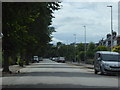
5
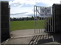
Access to Playing Fields
From Gladstone Place, Aberdeen.
Image: © Stanley Howe
Taken: 29 Apr 2010
0.07 miles
6

Granite suburban (Gladstone Place, Aberdeen)
The left-hand house has a distinct arts-and-crafts look (https://en.wikipedia.org/wiki/Arts_and_Crafts_movement ), which is unusual for Aberdeen.
Image: © Bill Harrison
Taken: 29 Dec 2013
0.08 miles
7
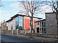
Albyn School annex and nursery
As seen from Forest Avenue
Image: © Bill Harrison
Taken: 29 Dec 2013
0.10 miles
8
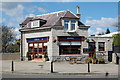
Suburban Restaurant
An unusual suburban location in Aberdeen for a restaurant (menu: Turkish).
Image: © Bill Harrison
Taken: 12 Apr 2011
0.12 miles
9

The Olive Tree, Aberdeen
This is a restaurant, on Queen's Road in Aberdeen's West End. Part of it was an old tollhouse that was then converted to a shop which ceased trading around 10 years ago. The glass extension was added in 2003.
Image: © Richard Slessor
Taken: 7 Oct 2006
0.12 miles
10
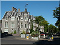
Queen's Gate, Aberdeen
This roundabout on Queen's Road is known as Queen's Gate. The turreted building, like many former residential properties on Queen's Road, has been converted to offices.
Image: © Richard Slessor
Taken: 7 Oct 2006
0.12 miles