IMAGES TAKEN NEAR TO
Dempsey Court, Queens Lane North, ABERDEEN, AB15 4DY
Introduction
This page details the photographs taken nearby to Dempsey Court, Queens Lane North, AB15 4DY by members of the Geograph project.
The Geograph project started in 2005 with the aim of publishing, organising and preserving representative images for every square kilometre of Great Britain, Ireland and the Isle of Man.

There are currently over 7.5m images from over14,400 individuals and you can help contribute to the project by visiting https://www.geograph.org.uk
Image Map
Images are licensed for reuse under creativecommons.org/licenses/by-sa/2.0
Notes
- Clicking on the map will re-center to the selected point.
- The higher the marker number, the further away the image location is from the centre of the postcode.
Image Listing (133 Images Found)
Images are licensed for reuse under creativecommons.org/licenses/by-sa/2.0
Image
Details
Distance
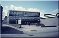
1
Flats on former Grampian TV site
Grampian TV lost its transmission rights to STV and the premises were sold off for flats. Formerly the site housed the Queens Cross tram sheds.
Image: © Ewen Rennie
Taken: 15 Sep 2010
0.03 miles
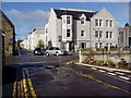
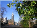
2
Queen's Lane North
The modern blocks on the right are Dempsey Court.
Image: © Anne Burgess
Taken: 13 Aug 2024
0.04 miles
3
Grampian Television Studios - Queens Cross
Now demolished and replaced by private housing, Grampian Television's studio centre near Queens Cross produced the nightly 'North Tonight' current affairs programme for many years, before moving to an industrial unit at Tullos. Grampian lost its identity in 2006 when it was subsumed into the transmission area of Scottish Television, after 44 years of doing their own 'thing'.
Image: © Raymond Okonski
Taken: 18 Apr 1984
0.04 miles
4
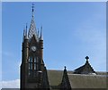
Rubislaw Church, Aberdeen
One of the many granite churches in Aberdeen
Image: © Isabella Perry
Taken: 16 Jun 2008
0.05 miles
5
Rubislaw Church from St. Swithin Street
Image: © Richard Slessor
Taken: 31 Jan 2006
0.05 miles
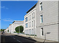
6
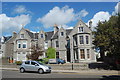
HSBC Commercial Bank, 2 Queen's Road, Aberdeen
Image: © Bill Harrison
Taken: 8 Jun 2014
0.06 miles
7
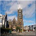
Rubislaw Parish Kirk
The established church in Aberdeen took a battering at the 1843 Disruption, but by the 1870s, it was preparing to expand (and also to compete with the Free Kirk): this B-listed church dating from ca. 1874 (see: http://www.britishlistedbuildings.co.uk/sc-19947-queen-s-cross-at-fountainhall-road-and-qu ) was established by the impressive sounding Aberdeen Church Extension and Territorial Home Mission Association and aided by "a number of gentlemen resident in the west-end (who) had seen the desirability of having an Established Church in the neighbourhood of Queen's Cross." The use of sandstone was highly unusual for Aberdeen.
Image: © Bill Harrison
Taken: 16 Mar 2014
0.06 miles
8
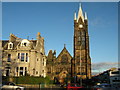
Rubislaw Parish Church
Rubislaw Parish Church was built in 1875. In 1961 a Church Centre was built nearby.
The Parish of Rubislaw is bounded by Queen's Road to the south, King's Gate to the north, Fountainhall Road to the east and Anderson Drive to the west. Rubislaw Church is at the corner of Queen's Gardens and Fountainhall Road, at the roundabout with the statue of Queen Victoria.
Image: © Colin Kinnear
Taken: 27 Jan 2011
0.07 miles
9
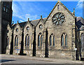
Rubislaw Church
The east elevation of Image] has an interesting feature, which is that the small round windows above the lancet windows in the four small gables are all different. From left to right, they are respectively trefoil, quatrefoil, cinquefoil and multifoil - or to put it another way they have, from left to right, three, four, five and six lobes.
Image: © Anne Burgess
Taken: 13 Aug 2024
0.07 miles
10
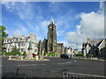
Rubislaw Parish Church
Rubislaw Parish Church viewed from across the Queen's Cross Roundabout.
Image: © Scott Cormie
Taken: 21 May 2022
0.07 miles