IMAGES TAKEN NEAR TO
Forest Road, ABERDEEN, AB15 4BT
Introduction
This page details the photographs taken nearby to Forest Road, AB15 4BT by members of the Geograph project.
The Geograph project started in 2005 with the aim of publishing, organising and preserving representative images for every square kilometre of Great Britain, Ireland and the Isle of Man.

There are currently over 7.5m images from over14,400 individuals and you can help contribute to the project by visiting https://www.geograph.org.uk
Image Map
Images are licensed for reuse under creativecommons.org/licenses/by-sa/2.0
Notes
- Clicking on the map will re-center to the selected point.
- The higher the marker number, the further away the image location is from the centre of the postcode.
Image Listing (99 Images Found)
Images are licensed for reuse under creativecommons.org/licenses/by-sa/2.0
Image
Details
Distance
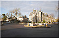
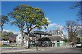
2
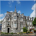
Granite block, Queen's Gate, Aberdeen
Typical West-End granite extravagance from the 1880s in the Scottish baronial style made fashionable by Balmoral. Now offices.
Image: © Bill Harrison
Taken: 8 Jun 2014
0.03 miles
3
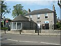
Former tollhouse
Surveyed by the Milestone Society. On the B9119 at 32-34 Queen's Road. The front of the building was the former Rubislaw Tollhouse. With the large 2 storey house attached behind it is now Aberdeen Drilling Consultants. There is a door to the left of the rounded front and the small chimney shows that the toll keeper could keep warm.
Image: © Alverie Weighill
Taken: 20 Apr 2019
0.03 miles
4

A 'Quantity Surveyors' office on Queens Road
Image: © Stanley Howe
Taken: 20 Nov 2009
0.04 miles
5
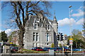
Granite mansion (now offices)
At the corner of Queen's Road and Forest Road
Image: © Bill Harrison
Taken: 12 Apr 2011
0.04 miles
6
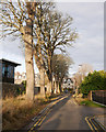
Spademill Road
A tree-lined street between Rubislaw Den South and Queen's Road. It is a one-way street, only a single lane wide.
Image: © Craig Wallace
Taken: 19 Jan 2020
0.04 miles
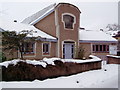
7
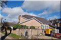
Christian Centre, Spademill Road, Aberdeen
For its website, see: http://www.thechristiancommunity.co.uk/1_level/addresses.htm .
Image: © Bill Harrison
Taken: 16 Mar 2014
0.04 miles
8
Spademill Road, Aberdeen
This short tree-lined lane connects Queen's Road (foreground) with Rubislaw Den South (in the distance).
Image: © Bill Harrison
Taken: 16 Mar 2014
0.04 miles
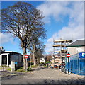
9
Roundabout, Queen's Road
The roundabout at Queen's Gate. It is the junction of Queen's Road with Forest Road / Forest Avenue.
Image: © Craig Wallace
Taken: 19 Jan 2020
0.04 miles
10
The Olive Tree
One of the more up-market (expensive) restaurants in Aberdeen, it closed without warning in January 2011.
Image: © Bill Harrison
Taken: 12 Apr 2011
0.05 miles