IMAGES TAKEN NEAR TO
Moray Place, ABERDEEN, AB15 4AF
Introduction
This page details the photographs taken nearby to Moray Place, AB15 4AF by members of the Geograph project.
The Geograph project started in 2005 with the aim of publishing, organising and preserving representative images for every square kilometre of Great Britain, Ireland and the Isle of Man.

There are currently over 7.5m images from over14,400 individuals and you can help contribute to the project by visiting https://www.geograph.org.uk
Image Map
Images are licensed for reuse under creativecommons.org/licenses/by-sa/2.0
Notes
- Clicking on the map will re-center to the selected point.
- The higher the marker number, the further away the image location is from the centre of the postcode.
Image Listing (24 Images Found)
Images are licensed for reuse under creativecommons.org/licenses/by-sa/2.0
Image
Details
Distance
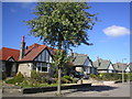
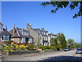
1
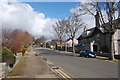
Moray Place, Aberdeen
This rather empty road connects Rubislaw Den North (out of sight to the right) with King's Gate (in the distance).
Image: © Bill Harrison
Taken: 23 Mar 2014
0.07 miles
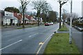
2
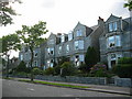
Kings Gate, Aberdeen
Granite houses on Kings Gate close to Anderson Drive. A popular route into the city from the west.
Image: © Lizzie
Taken: 3 Jun 2005
0.08 miles
4
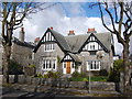
72 Rubislaw Den North, Aberdeen
A fine villa from ca. 1913 with vaguely Tudor styling; B-listed: http://www.britishlistedbuildings.co.uk/sc-20785-72-rubislaw-den-north-including-gatepiers .
Image: © Bill Harrison
Taken: 23 Mar 2014
0.11 miles
6
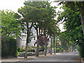
Rubislaw Den North
Tree-lined street in Aberdeen's West End. The granite mansions here and on the parallel Rubislaw Den South contain many of the best addresses in the city. Flowing between the two streets, at the bottom of their gardens, is the Denburn.
Image: © Colin Smith
Taken: 9 Jul 2010
0.13 miles
8
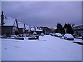
Carnegie Crescent, Aberdeen
Approx grid reference NJ912059.
Image: © Richard Slessor
Taken: 21 Mar 2006
0.14 miles
9

Scottish Baronial in the West End
Corbelling, crow-stepped gable and turret on a granite mansion in Rubislaw Den, the really upmarket area of Aberdeen.
Image: © Colin Smith
Taken: 9 Jul 2010
0.15 miles
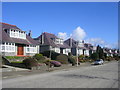
10
Morningfield Road, Aberdeen
Honeybrae, the cottage where Lord Byron spent his summer holidays in the 1790s, was situated near here (approx ref NJ915060). It was demolished, in the 1930s, to make way for these houses.
Image: © Richard Slessor
Taken: 13 May 2005
0.18 miles