IMAGES TAKEN NEAR TO
Eldenside, PETERCULTER, AB14 0XE
Introduction
This page details the photographs taken nearby to Eldenside, AB14 0XE by members of the Geograph project.
The Geograph project started in 2005 with the aim of publishing, organising and preserving representative images for every square kilometre of Great Britain, Ireland and the Isle of Man.

There are currently over 7.5m images from over14,400 individuals and you can help contribute to the project by visiting https://www.geograph.org.uk
Image Map
Images are licensed for reuse under creativecommons.org/licenses/by-sa/2.0
Notes
- Clicking on the map will re-center to the selected point.
- The higher the marker number, the further away the image location is from the centre of the postcode.
Image Listing (14 Images Found)
Images are licensed for reuse under creativecommons.org/licenses/by-sa/2.0
Image
Details
Distance
1
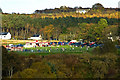
Crombie Park
Peterculter football pitch.
Image: © Alan Findlay
Taken: 17 Oct 2009
0.13 miles
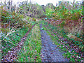
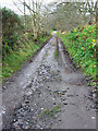
3
Culter House Road
Looking south east. A popular route for horse riders, runners and walkers. This section is south of Woodend.
Image: © Lizzie
Taken: 29 May 2005
0.17 miles
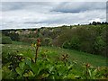
4
View NNW from Peterculter War Memorial
Across North Deeside road.
Image: © Stanley Howe
Taken: 20 May 2010
0.19 miles
6
View NNE from Peterculter War Memorial
Across the River Dee.
Image: © Stanley Howe
Taken: 20 May 2010
0.21 miles
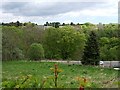
7
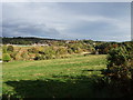
View towards Peterculter
From the A93 above Newmill.
Image: © Stanley Howe
Taken: 15 Oct 2007
0.22 miles
8
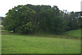
Woodland beside the Gormack Burn, Peterculter
Image: © Mike Pennington
Taken: 2 Aug 2012
0.23 miles

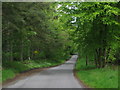
10
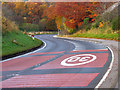
Nowsies corner
An S bend on the western approach to Peterculter known locally as Nowsies corner, (origin unknown).
Image: © Alan Findlay
Taken: 2 Nov 2007
0.24 miles