IMAGES TAKEN NEAR TO
St. Ronans Drive, PETERCULTER, AB14 0RB
Introduction
This page details the photographs taken nearby to St. Ronans Drive, AB14 0RB by members of the Geograph project.
The Geograph project started in 2005 with the aim of publishing, organising and preserving representative images for every square kilometre of Great Britain, Ireland and the Isle of Man.

There are currently over 7.5m images from over14,400 individuals and you can help contribute to the project by visiting https://www.geograph.org.uk
Image Map
Images are licensed for reuse under creativecommons.org/licenses/by-sa/2.0
Notes
- Clicking on the map will re-center to the selected point.
- The higher the marker number, the further away the image location is from the centre of the postcode.
Image Listing (18 Images Found)
Images are licensed for reuse under creativecommons.org/licenses/by-sa/2.0
Image
Details
Distance
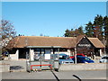
1
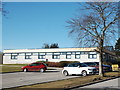
Peterculter Health Centre, Coronation Road, Peterculter
Image: © Bill Harrison
Taken: 28 Feb 2016
0.10 miles
3
(The) Ploughman, Peterculter
A 'real pub' built in the 1960s
Image: © Bill Harrison
Taken: 28 Feb 2016
0.15 miles
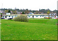
4
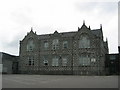
Culter Primary school
Known locally as Culter (pronounced "Cooter") - this is Peterculter primary school, the nursery is on the same site.
Image: © Lizzie
Taken: 29 May 2005
0.18 miles