IMAGES TAKEN NEAR TO
PETERCULTER, AB14 0PR
Introduction
This page details the photographs taken nearby to AB14 0PR by members of the Geograph project.
The Geograph project started in 2005 with the aim of publishing, organising and preserving representative images for every square kilometre of Great Britain, Ireland and the Isle of Man.

There are currently over 7.5m images from over14,400 individuals and you can help contribute to the project by visiting https://www.geograph.org.uk
Image Map
Images are licensed for reuse under creativecommons.org/licenses/by-sa/2.0
Notes
- Clicking on the map will re-center to the selected point.
- The higher the marker number, the further away the image location is from the centre of the postcode.
Image Listing (14 Images Found)
Images are licensed for reuse under creativecommons.org/licenses/by-sa/2.0
Image
Details
Distance
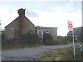
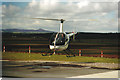
1
Culter Helipad
You can go here for short lessons on how to fly a helicopter.
Image: © Carol Walker
Taken: Unknown
0.05 miles
2
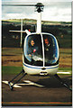
It's like a bubble!
One of the tiny helicopters used for flying instruction. Scary stuff!
Image: © Carol Walker
Taken: Unknown
0.05 miles
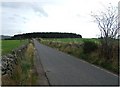
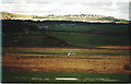
5
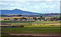
Roadside of Garlogie
A telephoto view of the village on the B9119. Benachie in the distance.
Image: © Alan Findlay
Taken: 26 Apr 2010
0.10 miles