IMAGES TAKEN NEAR TO
PETERCULTER, AB14 0PL
Introduction
This page details the photographs taken nearby to AB14 0PL by members of the Geograph project.
The Geograph project started in 2005 with the aim of publishing, organising and preserving representative images for every square kilometre of Great Britain, Ireland and the Isle of Man.

There are currently over 7.5m images from over14,400 individuals and you can help contribute to the project by visiting https://www.geograph.org.uk
Image Map
Images are licensed for reuse under creativecommons.org/licenses/by-sa/2.0
Notes
- Clicking on the map will re-center to the selected point.
- The higher the marker number, the further away the image location is from the centre of the postcode.
Image Listing (11 Images Found)
Images are licensed for reuse under creativecommons.org/licenses/by-sa/2.0
Image
Details
Distance
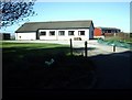
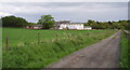
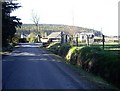
5
Approach to Easter Anguston farm
From the north.
Image: © Stanley Howe
Taken: 11 Apr 2009
0.04 miles
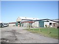
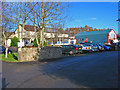
6
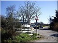
Access to Linn Moor Home
A VSA residential school for children with learning difficulties.
Image: © Stanley Howe
Taken: 11 Apr 2009
0.16 miles
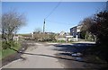
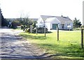
8
Linn Moor Residential School
Linn Moor School, near Peterculter, provides residential education for children with special needs.
Image: © Colin Walker
Taken: 29 May 2005
0.17 miles
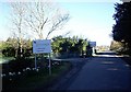
10
Linn Moor School
Residential school, for children with learning difficulties, operated by Voluntary Services Aberdeen.
Image: © Alan Findlay
Taken: 12 Nov 2007
0.20 miles