IMAGES TAKEN NEAR TO
Burnside Road, PETERCULTER, AB14 0LP
Introduction
This page details the photographs taken nearby to Burnside Road, AB14 0LP by members of the Geograph project.
The Geograph project started in 2005 with the aim of publishing, organising and preserving representative images for every square kilometre of Great Britain, Ireland and the Isle of Man.

There are currently over 7.5m images from over14,400 individuals and you can help contribute to the project by visiting https://www.geograph.org.uk
Image Map
Images are licensed for reuse under creativecommons.org/licenses/by-sa/2.0
Notes
- Clicking on the map will re-center to the selected point.
- The higher the marker number, the further away the image location is from the centre of the postcode.
Image Listing (56 Images Found)
Images are licensed for reuse under creativecommons.org/licenses/by-sa/2.0
Image
Details
Distance
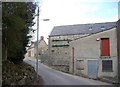
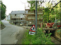
3
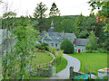
Lower Kennerty Mill
A historic oatmeal mill on the Culter Burn, ruined in 1880 but reconstructed as a barley mill. After it ceased to be used as a mill in 1916 it was used as an engineering works. Rebuilt again 1940 and in operation briefly until November 1941. (Precis of listing). Listed category C (LB15718). Viewed from the Deeside Way.
Image: © Stephen Craven
Taken: 2 Jul 2019
0.06 miles
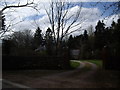
4
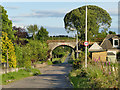
Former railway bridge over Burnside Road
The bridge, with an indicated clearance of 14ft, now carries the Deeside Way.
Image: © Stephen Craven
Taken: 2 Jul 2019
0.07 miles
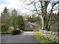
6
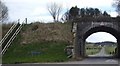
Rail Bridge, Kennerty
Which carried the former Deeside Railway over the road to the Golf Club.
Image: © Stanley Howe
Taken: 22 Apr 2010
0.09 miles
7
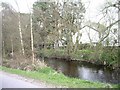
Tail race of Upper Kennerty Mills
See Image for the mill buildings.
Image: © Stephen Craven
Taken: 2 Jul 2019
0.09 miles
8
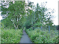
The Deeside Way at Burnside
Once a railway line, now part of the National Cycle Network.
Image: © Stephen Craven
Taken: 2 Jul 2019
0.10 miles