IMAGES TAKEN NEAR TO
Broad Street, ABERDEEN, AB12 9SD
Introduction
This page details the photographs taken nearby to Broad Street, AB12 9SD by members of the Geograph project.
The Geograph project started in 2005 with the aim of publishing, organising and preserving representative images for every square kilometre of Great Britain, Ireland and the Isle of Man.

There are currently over 7.5m images from over14,400 individuals and you can help contribute to the project by visiting https://www.geograph.org.uk
Image Map
Images are licensed for reuse under creativecommons.org/licenses/by-sa/2.0
Notes
- Clicking on the map will re-center to the selected point.
- The higher the marker number, the further away the image location is from the centre of the postcode.
Image Listing (853 Images Found)
Images are licensed for reuse under creativecommons.org/licenses/by-sa/2.0
Image
Details
Distance
1
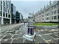
Light the North Trail
The Light the North lighthouse trail took people on a cultural tour of the north-east of Scotland, including Moray, Orkney and Shetland. Visitors discovered over 45 lighthouse sculptures designed and created by some of the area’s most talented artists.
The trail raised awareness and funds for the most significant cancer support charity in the region, CLAN Cancer Support. The charity shined a light of hope in the dark for anyone affected by cancer.
Image: © Ralph Greig
Taken: 20 Aug 2021
0.01 miles
2
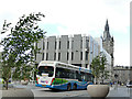
Hydrogen bus in Broad Street, Aberdeen
A new approach to emissions-free travel.
Image: © Stephen Craven
Taken: 2 Jul 2019
0.02 miles
3
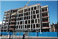
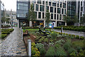
Marischal Square (under construction)
The controversial office and retail development on the site of City Council offices. The overpowering block (and another to the right) totally overshadow the late medieval Provost Skene's House, just visible to the right in this view.
Image: © Bill Harrison
Taken: 13 Aug 2016
0.02 miles

5
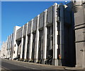
Town House annex, Broad Street, Aberdeen
Built ca. 1975 in brutalist style as an extension to the A-listed Flemish gothic main Town House just visible to the right.
Image: © Bill Harrison
Taken: 1 Mar 2014
0.02 miles
6
Turf Zone "Skenehouse"
Off Flourmill Lane, Aberdeen.
Image: © Ian S
Taken: 4 Oct 2022
0.03 miles
7
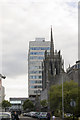
Loved and loathed...
The 1960's tower block of St Nicholas House looms behind the ornate granite spires of Greyfriars Kirk. St Nicholas House is the main office of Aberdeen City Council and is scheduled for demolition when Marischal College is refurbished. Greyfriars Kirk is the southern end of the Marischal College complex - the world's second largest granite building, after the Escorial.
Image: © Bill Harrison
Taken: 15 Jun 2008
0.03 miles
8
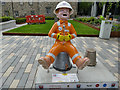
Oor Roughneck, Marischal Square, Aberdeen
This version of the figure, illustrated as a construction worker, was by Catriona MacKenzie.
Image: © Stephen Craven
Taken: 2 Jul 2019
0.03 miles
9
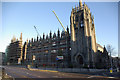
Marischal College
Seen from Broad Street, Marischal College was one of the two colleges that came together in 1860 to form the University of Aberdeen. This building dates from 1837-44, although the foundation of the college is much older. It is said to be the second largest granite building in the world, but it is no longer used by the university and has been leased to Aberdeen City Council who will use it as their new headquarters. However, this has meant the demolition of all but the facade of the building and the large cranes bear testimony to the work that is taking place.
Image: © Stephen McKay
Taken: 7 Nov 2009
0.03 miles
10

The Illicit Still Public House
On Broad Street, Aberdeen.
Image: © Ian S
Taken: 4 Oct 2022
0.03 miles